| A PICTURE IS WORTH A THOUSAND WORDS |
MOVE MOUSE OVER MAP CAMERA ICONS  TO VIEW PHOTOS - F5 TO REFRESH TO VIEW PHOTOS - F5 TO REFRESH |
 |
 |
MOVE MOUSE OVER  TO VIEW QUICK-LINK MAP TO VIEW QUICK-LINK MAP
CLICK ON ANY HIKE ICON TO JUMP TO THAT HIKE |
|
|
|
| Hike Length: |
13.5 miles round trip |
| Elev. Change: |
2000' gain |
| Hike Difficulty: |
Challenging |
| Type of Hike: |
In and Out with Loop |
| Season: |
Mid-Summer thru Fall |
|
| Trail Numbers: |
#96, 97, 2000 |
| Trail Condition: |
Good |
| Trail Access: |
Excellent |
| Trail Signage: |
Good |
| Features: |
Views, Wildflowers |
|
| Pet Friendly: |
Yes |
| Useage: |
Very Heavy |
| Permit: |
NW FP Required |
| Horses: |
Yes |
| Mtn Bikes: |
No |
|
|
Summary:
Press CTRL + P to print. Photos do not show when you print this page. (Help)

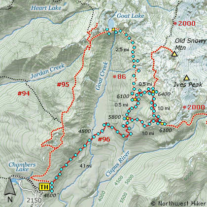
This hike begins on Forest Road #2150.040 near what is
commonly referred to as the Berry Patch. The trail
climbs gently for the first half mile then begins a
slow descent to Goat Creek. Most of this part of the
hike is in dense forest with very few view opportunities.
After crossing the creek the trail begins to climb
steeply through a number of switchbacks and talus
slopes toward Snowgrass Flats. At about 4 miles,
just before entering Snowgrass Flats, bypass Trail
#97 heads east as an alternate route allowing the
hiker to do a loop hike.
Taking the bypass trail, you will encounter some of
the most amazing floral displays anywhere in the
Goat Rocks Wilderness, if you get there in mid-July.
This bypass trail is a mile long and crosses a small
stream on its way to the Pacific Crest Trail #2000.
When you reach the PCT, bear left and follow it
another 2 miles to the junction with the Snowgrass
Flats Trail #96.
Follow Trail #96 back down to Snowgrass Flats and
return the way you came after passing the bypass
Trail #97.
|
|
The following images are random samples of the wildflowers found in the Gifford Pinchot National Forest.
Mouseover image to view flower name, and click on image to jump to flower guide.
|
Directions:
From I-5 junction with US Hwy 12
Travel east on US Hwy 12 for about 48 miles to Randle.
From Randle travel east on US Hwy 12 for about 13.3 miles to the junction with
Forest Road 21. Turn right (south) onto FR21 and follow it uphill for about 5 miles.
At this point you will see Forest Road 2110 on your left, which is the road to the
Glacier Lake trailhead, but you continue straight ahead on FR21. In another 8.1 miles
you will come to the junction of Forest Road 2150. Bear left onto FR2150 and follow it
about 3 miles and you will pass the junction on your left which leads to the
Chamber Lake campground. Continue ahead just a short distance, and you will come to
a spur road on your right. This is the entrance to what is referred to as the
Snowgrass Flats trailhead. This hike and many more begin here.
Click on the link below to see a map taking you to the trailhead.
|
|

