| A PICTURE IS WORTH A THOUSAND WORDS |
MOVE MOUSE OVER MAP CAMERA ICONS  TO VIEW PHOTOS - F5 TO REFRESH TO VIEW PHOTOS - F5 TO REFRESH |
 |
 |
MOVE MOUSE OVER  TO VIEW QUICK-LINK MAP TO VIEW QUICK-LINK MAP
CLICK ON ANY HIKE ICON TO JUMP TO THAT HIKE |
|
|
|
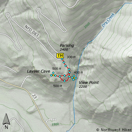
| Hike Length: |
1/4 miles round trip |
| Elev. Change: |
100' gain |
| Hike Difficulty: |
Easy |
| Type of Hike: |
Loop |
| Season: |
Spring thru Fall |
|
| Trail Numbers: |
#290 |
| Trail Condition: |
Good |
| Trail Access: |
Excellent |
| Trail Signage: |
Good |
| Features: |
Views, Wildflowers, Cave |
|
| Pet Friendly: |
Not really |
| Useage: |
Moderate |
| Permit: |
No NW FP Required |
| Horses: |
No |
| Mtn Bikes: |
No |
|
|
Summary:
Press CTRL + P to print. Photos do not show when you print this page. (Help)
This hike begins on Forest Road #2300.084. Actually,
this should be called a walk, not a hike. It is only
800 feet from the parking area to the entrance of
the cave.
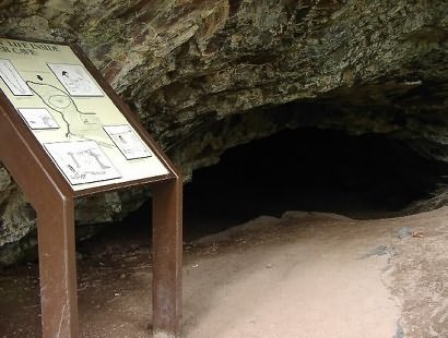
Layser Cave is one of the most significant archaeological
sites in western Washington. The cave was discovered by
forest worker, Tim Layser in 1982.
The cave is only about 60 x 40 feet in size. Experts
have determined that the cave was used for thousands
of years by native peoples dating back as much as
5000 years. The cave appeared to be abandoned with
no apparent cause over 300 years ago.
|
|
The following images are random samples of the wildflowers found in the Gifford Pinchot National Forest.
Mouseover image to view flower name, and click on image to jump to flower guide.
|
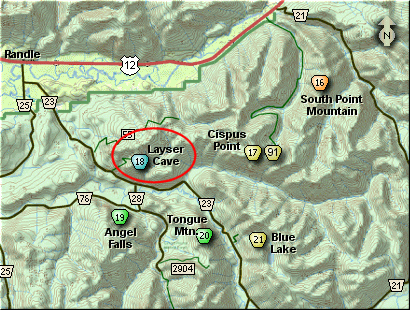
Directions:
From I-5 junction with US Hwy 12
Travel east on US Hwy 12 for about 48 miles to Randle.
From Randle, travel south on State Road 131, crossing the Cowlitz River and in a mile
you will come to Cispus Road on your left. Bear left and follow Cispus Road, which become
Forest Road 23, for another 5.2 miles and you will pass Forest Road 55 on your left.
Continue on another mile and you will find Forest Road 083 on your left. Turn left onto
FR083 and follow it uphill for about 1.2 miles. You will come to a large sweeping switchback,
where you can park in the inside area of the switchback. The trailhead for this hike
is just across the road.
Click on the link below to see a map taking you to the trailhead.
|
|


