Volcano Alert
Click Volcanic Alert to discover if there are any current safety concerns.
Summary:
Press CTRL + P to print. Photos do not show when you print this page. (Help)
Actually, Mt St Helens can be climbed any
time of year. However, regardless of when
you climb this mountain, you must obtain
a climbing permit. Permits are available
at Jacks Restaurant and Store on Hwy 503
at Yale, Washington (360-231-4276). From
May 15 thru October 31 there are 100 permits
per day. 50 of these permits are available
on a reservation basis. 50 are available
on a daily first come first serve basis.
The permits cost $15 per day. An annual
permit can be obtain for $30. Contact
the Forest Service for specifics.
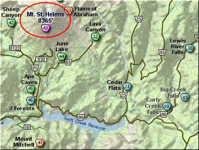
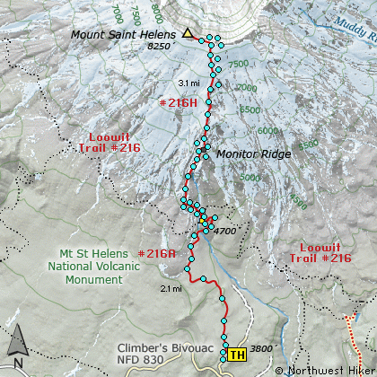
Once you have your permit, drive to the
trail head for the climb at a place called
Climbers Bivouac which is at the end of
Forest Road #830. Depending on the time
of year, the trail to the top of Mt St
Helens can be covered with varying amounts
of snow. I climbed the mountain on July 22,
and never had to walk on snow.
The trail is well marked both in the
forested areas as well as on the mountain
itself. On the mountain the trail is
designated by tall posts. As you begin
the hike/climb you will hike for the
first couple miles in dense forest.
The trail gets increasingly steeper each
step of the way.
At a couple miles you will cross the Loowit
Trail that circles Mt St Helens. There is
a restroom there for your convenience. Then
the trail gets very steep. You remain in
the trees for another half mile or so, then
you break out into the open. At this point
you must find your way to the top of the
mountain by following the pole markers well
placed almost all the way. The trail follow
Monitor Ridge to the top of the mountain.
The steepness is not the most difficult part
of this hike. It seems to me that negotiating
your way through the lava boulders is the greatest
challenge, especially when you are coming down
the mountain. Never the less, this hike is so
very worth it. It just doesn't get any better
than this. There are no technical aspects
of this hike, and yet you end up on top of a
real mountain.
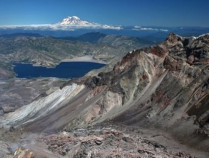
Of course the views are everything.
|