Search Northern Central Goat Rocks Mt Adams SE Hikes SW Hikes St Helens Hike List Return
Hike 46 Trail of 2 Forests Main Menu
A PICTURE IS WORTH A THOUSAND WORDS MOVE MOUSE OVER MAP CAMERA ICONS TO VIEW PHOTOS - F5 TO REFRESH
MOVE MOUSE OVER TO VIEW QUICK-LINK MAP
CLICK ON ANY HIKE ICON TO JUMP TO THAT HIKE
Print Topo Map Hike Difficulty
Calculator
 
Legend Ten Essentials  

Hike Length: 3/10 miles round trip
Elev. Change: None
Hike Difficulty: Easy
Type of Hike: Boardwalk Loop
Season: Year Round
Trail Numbers: #233
Trail Condition: Good
Trail Access: Excellent
Trail Signage: N/A
Features: Tree Casts in Lava
Pet Friendly: Not Allowed
Useage: Heavy
Permit: NW FP Required
Horses: No
Mtn Bikes: No

 Volcano Alert    Click Volcanic Alert to discover if there are any current safety concerns.

Summary:
Press CTRL + P to print. Photos do not show when you print this page. (Help)


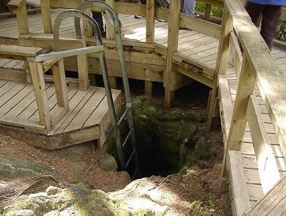
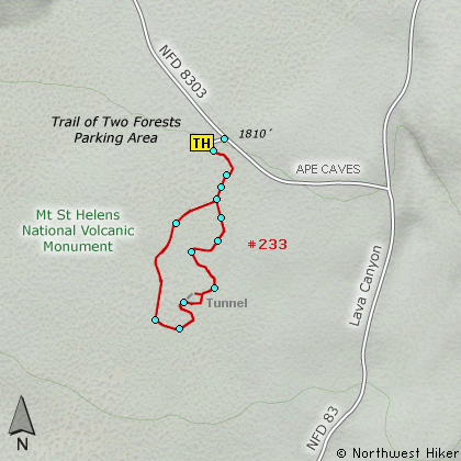
This boardwalk trail is located through a 1900 year old lava flow. The scenic loop takes you to many examples of the vertical molds left behind when hot lava flowed through a living forest and surrounded the base of the trees. After the trees burned up, there was a hole left where they had been, and those holes, or molds, are visible to us today.

There are even some horizontal molds where the lave flowed over fallen trees, and when they burned up, a holes were left in there place. Some of these holes are large enough for visitors to crawl through.

As you can imagine, this area is extremely fragile, so please walk only where indicated.


The following images are random samples of the wildflowers found in the Gifford Pinchot National Forest.
Mouseover image to view flower name, and click on image to jump to flower guide.

Directions:

From Woodland, WA
From the junction with I-5 follow SR503 east from Woodland, WA approximately 23 miles to the junction of the Lewis River Road with SR503. Continue east on the Lewis River Road another 4.4 miles to the junction of Forest Road 81 just before you get to Cougar. Continue east through Cougar on the Lewis River Road, which becomes Forest Road 90, for about 7.4 miles to the junction of Forest Roads 90 and 83. Turn left on FR83. In about 1.7 miles you will come to Forest Road 8303, which leads to the Trail of Two Forests Interpretive Site. Turn left on FR8303 and follow it for about a quarter mile to the entrance and parking area for this hike.


Click on the link below to see a map taking you to the trailhead.

Map Directions


Vicinity Map


To contact the Gifford Pinchot NF for current information: Click Here.


A Virtual Hike in the Gifford Pinchot National Forest
Click for PDF
Click for PDF