| A PICTURE IS WORTH A THOUSAND WORDS |
MOVE MOUSE OVER MAP CAMERA ICONS  TO VIEW PHOTOS - F5 TO REFRESH TO VIEW PHOTOS - F5 TO REFRESH |
 |
 |
MOVE MOUSE OVER  TO VIEW QUICK-LINK MAP TO VIEW QUICK-LINK MAP
CLICK ON ANY HIKE ICON TO JUMP TO THAT HIKE |
|
|
|
| Hike Length: |
8.4 miles round trip |
| Elev. Change: |
400' gain |
| Hike Difficulty: |
Moderate |
| Type of Hike: |
In and Out |
| Season: |
Spring thru Fall |
|
| Trail Numbers: |
#130 |
| Trail Condition: |
Good |
| Trail Access: |
Varies |
| Trail Signage: |
Poor |
| Features: |
River, Wildflowers, Waterfalls |
|
| Pet Friendly: |
Yes |
| Useage: |
Heavy |
| Permit: |
NW FP Required |
| Horses: |
No |
| Mtn Bikes: |
No |
|
|
Summary:
Press CTRL + P to print. Photos do not show when you print this page. (Help)
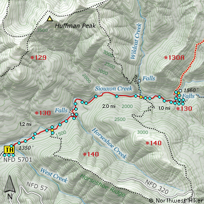
The hike up Siouxon Creek
(pronounced Sou-sawn) can be
a refreshingly pleasant walk
along a beautiful mountain
stream. The trail can be used
by mountain bikers so be alert.
All of the bikers I encountered
were very courteous and respectful.
From the trail head at the end
of Forest Road #5701, the trail
drops immediately toward Siouxon
Creek in the valley below. The
trail crosses a number of smaller
creeks that flow into Siouxon
Creek. Any of the streams of
any size have excellent bridges.
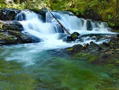
One of the fun things about this
hike are the refreshing views
around every bend in the creek.
Siouxon Creek is wide and shallow
in places and narrow and swift in
other places. Then there are the
falls along the way. Some of
the smaller streams flowing into
Siouxon Creek have falls that are
visible from the trail, and then
Siouxon Creek has falls of its
own.
Then at the end of the hike,
you will cross Siouxon Creek on
a very fine bridge and the trail
splits. Trail #130 continues up
Siouxon Creek, but follow Trail #130A
up Chinook Creek for about a
quarter mile to view the beautiful
Chinook Creek Falls.
|
|
The following images are random samples of the wildflowers found in the Gifford Pinchot National Forest.
Mouseover image to view flower name, and click on image to jump to flower guide.
|
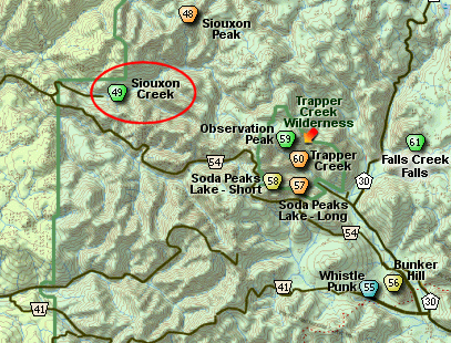
Directions:
from Woodland, WA
From Woodland, WA travel east on the NE Cedar Creek Road for about 16.4 miles,
and you will come to the junction of NE 221st Ave, which goes into the town
of Amboy. Just keep straight ahead on the Cedar Creek Road and in another
mile and a half you will join SR 503. Continue east on SR503 for another
2.2 miles to the junction of Healy Road. Turn right and head east on Healy Road
for 2.3 miles where the road becomes Forest Road 54. Continue easterly on
FR54 for another 6.8 miles where it intersects Forest Road 57. Bear left on
FR57 and go another 1.2 miles where it intersects with Forest Road 5701.
Follow FR5701 clear to the end where you will find the trailhead to this hike.
Note that recently FR5701 was washed out by a slide, but it was passable at the
time of this writing.
Click on the link below to see a map taking you to the trailhead.
|
|


