Search Northern Central Goat Rocks Mt Adams SE Hikes SW Hikes St Helens Hike List Return
Hike 58 Soda Peak Lake via Soda Peak Ridge Main Menu
A PICTURE IS WORTH A THOUSAND WORDS MOVE MOUSE OVER MAP CAMERA ICONS TO VIEW PHOTOS - F5 TO REFRESH
MOVE MOUSE OVER TO VIEW QUICK-LINK MAP
CLICK ON ANY HIKE ICON TO JUMP TO THAT HIKE
Print Topo Map Hike Difficulty
Calculator
 
Legend Ten Essentials  

Hike Length: 4.4 miles round trip
Elev. Change: 1300' cumulative gain
Hike Difficulty: Challenging
Type of Hike: In and Out
Season: Summer thru Fall
Trail Numbers: #133
Trail Condition: Fair to Good
Trail Access: Very Good
Trail Signage: None
Features: Views, Wildflowers, Lakes
Pet Friendly: Yes
Useage: Heavy
Permit: NW FP NOT Required
Horses: No
Mtn Bikes: No

Summary:
Press CTRL + P to print. Photos do not show when you print this page. (Help)


This hike begins off Forest Road #54. The trail head is very marked. This is an exceptionally outstanding hike. It is a bit steep, but short enough to not matter.

The trail begins by gently climbing across an open area before entering the forest. Because this area outside of the wilderness has been heavily logged you will have several open areas with excellent views.

The trail gains about 700' before reaching the ridge above Soda Peaks Lake. You can see the lake below you as you look out at the eastern Soda Peak. Now the trail descends rather rapidly to the lake via a long circular switchback.

When you get to the lake, it is well worth it to walk over to the eastern side and climb a bit up the rocky side of the east Soda Peak. The views from there add to your reward for coming to this beautiful little lake.


The following images are random samples of the wildflowers found in the Gifford Pinchot National Forest.
Mouseover image to view flower name, and click on image to jump to flower guide.

Directions:

from Portland, OR
From Portland, travel east on Interstate Hwy 84 to Exit 44 to Cascade Locks. Exit the freeway and cross over the Columbia River into Washington via the Bridge of the Gods. Then turn right, or east, and head east through Stevenson, Washington to the intersection of the Wind River Highway to Carson, Washington. Bear left onto the Wind River Highway which will take you through Carson, Washington.

from Vancouver, WA
From Vancouver, WA travel east on SR14 through Stevenson, Washington to the intersection of the Wind River Highway to Carson, Washington. Bear left onto the Wind River Highway which will take you through Carson, Washington.

from Carson, WA
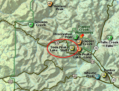
Continue north on the Wind River Highway (FR30) for about 8.6 miles to the little community of Stabler and the junction with Forest Road 43, also called Hemlock Road. Turn left onto FR43 and cross a bridge over the Wind River and continue west for a short ways and you will come to the junction of Forest Road 54 which is also called the Szydlo Road. Turn right and follow this road another 3.9 miles to a junction with Forest Road 5401 which is also called Little Soda Springs Road. Bear left and continue steeply up FR54. In another 2.7 miles you will come to the junction of Forest Road 42, but bear to the right and continue climbing on FR54.

FR54 will continue climbing and circling Soda Peaks to the west for another 6.8 miles. You will then come to a spur road off to your right that is very 
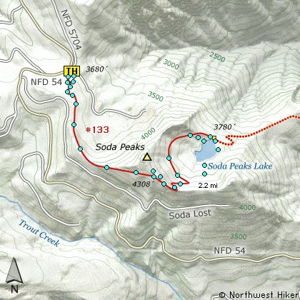
clearly the parking area for this hike. The trailhead is labeled and you can register for wilderness travel there.


Click on the link below to see a map taking you to the trailhead.

Map Directions


Vicinity Map


To contact the Gifford Pinchot NF for current information: Click Here.


A Virtual Hike in the Gifford Pinchot National Forest
Click for PDF
Click for PDF