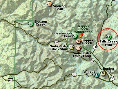
Search Northern Central Goat Rocks Mt Adams SE Hikes SW Hikes St Helens Hike List Return
Hike 61 Falls Creek Falls Main Menu
A PICTURE IS WORTH A THOUSAND WORDS MOVE MOUSE OVER MAP CAMERA ICONS TO VIEW PHOTOS - F5 TO REFRESH
MOVE MOUSE OVER TO VIEW QUICK-LINK MAP
CLICK ON ANY HIKE ICON TO JUMP TO THAT HIKE
Print Topo Map Hike Difficulty Calculator Vertical Pano
Legend Ten Essentials  

Hike Length: 3.4 miles round trip
Elev. Change: 600' gain
Hike Difficulty: Moderate
Type of Hike: In and Out
Season: Spring thru Fall
Trail Numbers: #152-A, 152
Trail Condition: Good
Trail Access: Very Good
Trail Signage: Good
Features: Waterfall
Pet Friendly: Not really
Useage: Heavy
Permit: NW FP NOT Required
Horses: No
Mtn Bikes: Yes

Summary:
Press CTRL + P to print. Photos do not show when you print this page. (Help)


This excellent little hike begins off Forest Road #057. The trail is gentle and well used. You will climb a bit at first and then in about a half mile you will come to a unique suspension bridge that spans Falls Creek.

After crossing the creek, the trail parallels the creek all the way to the base of the lower falls. There will be times you can see the creek as you hike along, but most of the time you are high enough above it that you can only hear it. As you near the end of the trail you will break out onto a rocky cliff area where you get great glimpses of the upper falls.

About 3/4 of a mile from the suspension bridge, you will come to a cut-off-trail that leads uphill to Trail #152. This is well worth the short steep climb, if you follow Trail #152 eastward for about a half mile. From there you can walk off trail on your right to a steep cliffy area with exceptional views.


However, after passing the junction to the upper trail, you reach the end of Trail #152A, and you will be at the base of Falls Creek Falls. You can see the upper falls, but not nearly as well as the lower falls right in front of you.


The following images are random samples of the wildflowers found in the Gifford Pinchot National Forest.
Mouseover image to view flower name, and click on image to jump to flower guide.

Directions:

from Portland, OR
From Portland, travel east on Interstate Hwy 84 to Exit 44 to Cascade Locks. Exit the freeway and cross over the Columbia River into Washington via the Bridge of the Gods. Then turn right, or east, and head east through Stevenson, Washington to the intersection of the Wind River Highway to Carson, Washington. Bear left onto the Wind River Highway which will take you through Carson, Washington.

from Vancouver, WA
From Vancouver, WA travel east on SR14 through Stevenson, Washington to the intersection of the Wind River Highway to Carson, Washington. Bear left onto the Wind River Highway which will take you through Carson, Washington.

from Carson, WA
Continue north on the Wind River Highway (FR30) for about 8.6 miles to the little community of Stabler and the junction with Forest Road 43, also called Hemlock Road. Continue northwest on FR30 for another 5.4 miles and you will pass a fish hatchery on the left. Continue on another half mile and you will come to the junction with Forest Road 3065, which continues straight ahead.

Turn right continue north on FR30 for another 0.8 miles and you will come to Forest Road 3062 on your right. Turn onto FR3062 and follow it another 2.4 miles until you come to a spur off this road on your right numbered FR057. Turn right onto this spur and follow it a short distance to the parking area and trailhead for this hike.


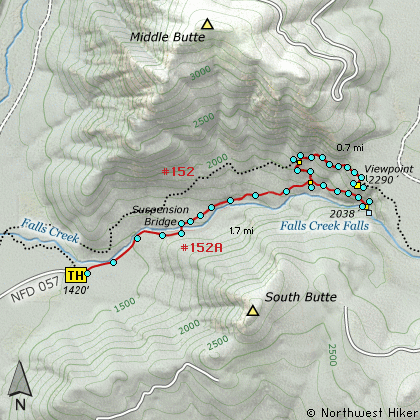
Click on the link below to see a map taking you to the trailhead.

Map Directions


Vicinity Map


To contact the Gifford Pinchot NF for current information: Click Here.


A Virtual Hike in the Gifford Pinchot National Forest
Click for PDF
Click for PDF