| A PICTURE IS WORTH A THOUSAND WORDS |
MOVE MOUSE OVER MAP CAMERA ICONS  TO VIEW PHOTOS - F5 TO REFRESH TO VIEW PHOTOS - F5 TO REFRESH |
 |
 |
MOVE MOUSE OVER  TO VIEW QUICK-LINK MAP TO VIEW QUICK-LINK MAP
CLICK ON ANY HIKE ICON TO JUMP TO THAT HIKE |
|
|
|
| Hike Length: |
5.5 miles round trip |
| Elev. Change: |
1200' gain |
| Hike Difficulty: |
Moderate |
| Type of Hike: |
In and Out |
| Season: |
Summer thru Fall |
|
| Trail Numbers: |
#33, 33-A |
| Trail Condition: |
Good |
| Trail Access: |
Good |
| Trail Signage: |
Good |
| Features: |
Views, Wildflowers, Lakes |
|
| Pet Friendly: |
Yes |
| Useage: |
Heavy |
| Permit: |
NW FP Required |
| Horses: |
Yes |
| Mtn Bikes: |
No |
|
|
Summary:
Press CTRL + P to print. Photos do not show when you print this page. (Help)

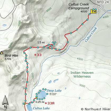
This is another hike that begins in the
Cultus Creek Campground. Follow Trail #33
as it climbs steeply out of the valley.
In the first mile you will gain several
hundred feet in elevation. A few well
placed switchbacks make the climb easier.
At about 1 mile you will come to a
sharp switchback with a view. From
here you will be treated to an outstanding
view of Mt Adams to the northeast, with
Sleeping Beauty just below it to the right.
The Goat Rocks can be seen to the north,
and Mt Rainier to the northeast.
The trail climbs more gently for the next
mile as it wanders in and out of forested
areas. At about 2 miles you will be
right below the ridgeline of Bird Mountain.
A half mile later you will come to the
junction of Trail #33A which takes you to
Deep Lake.
The trail to deep lake wanders up and down
and in and out of forested areas before it
reaches the lake. When you come to the
lake, take time to explore all shorelines.
The best views are probably from the south
and southeast side of the lake, where you
can see Mt Adams peeking over the forested
northern shore of the lake.
|
|
The following images are random samples of the wildflowers found in the Gifford Pinchot National Forest.
Mouseover image to view flower name, and click on image to jump to flower guide.
|
Directions:
From Portland, OR
From Portland, travel east on Interstate Hwy 84 to Exit 64 at Hood River.
Turn left, and pass under the freeway and cross the toll bridge ($1.00)
into Washington state. Turn left onto SR14 and drive approximately 1.5
miles to state road 141 Alt. Turn right onto SR141 Alt. and follow it another
2 miles and merge bearing left onto SR141. Then travel north on SR141
for another 19 miles to Trout Lake and the junction to Mt. Adams Road,
which heads north to other hike destinations.
from Trout Lake, WA
Bear left and continue on SR141 westbound out of Trout Lake for about
5.5 miles and you will cross into the Gifford Pinchot National Forest
and the road changes to Forest Road 24. Continue westward on FR24 for
another 2.5 miles and you will come to the junction where FR24 turns
north. Turn right and continue to follow FR24 north for another 5 miles
and you will pass the trailhead for Wapiki Lake. Continue on SR24 for
another 4 miles and you will come to Cultus Campground on your left.
Enter the campground and look for the parking area and trailhead for
this hike.
Click on the link below to see a map taking you to the trailhead.
|
|


