Summary:
Press CTRL + P to print. Photos do not show when you print this page. (Help)
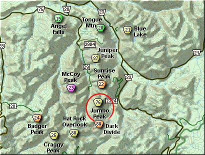
This hike begins off Forest Road 2324.063 which is
off Forest Road 23. This hike begins at the same
trail head as the hike to Sunrise Peak. Be aware
that this area is open to motorized
vehicles, so
you are likely to encounter motor-bikes.
The hike begins very very steep. Even
though your first steps are downhill, don't let that
fool you. The next quarter mile is straight UP!
The hike begins in a very dense forest, but after
about a half mile you break out into the open
where you will remain for the balance of the hike.
Wildflowers are extremely abundant in season and
add a great deal of enjoyment to this hike. Also,
for most of this hike, you will have fantastic views
of Mt Adams to the east.
At about 1 mile you come to a junction to Trail #261A
which leads to the top of Sunrise Peak. Bear straight
ahead and follow the trail slightly downhill where
in another half mile you will come to the Juniper
Ridge Trail. Bear left.
The trail will continue to descend just a bit
until it reaches the base of a cliffy area. Then
the trail begins a rather serious climb along the
northwestern side of these cliffs.
In another half mile you will come out onto a more
level area with excellent views of Jumbo Peak to the
south of you. From here you can see your trail in
the distance as it climbs around yet another hilly
area.
The trail is fairly level for the next half mile.
Then the climbs continues up the northwest side of
another hilly area. All along this stretch of the
hike you will be face to face with a very large
and very steep cliff. The trail does not get very
close to this cliff but the views of it are very
impressive as you hike along.
After this next climb, the trail comes out at the
base of Jumbo Peak. It then takes you on a long
route to the northwest, west, then south side of
the peak. As you skirt the west side of Jumbo Peak,
you will see an old worn trail that follows up
the west and northwest flank of the mountain. You
will want to return to this trail after you have
explored the south side of Jumbo Peak. It is this
trail that will lead you to the top of the peak.
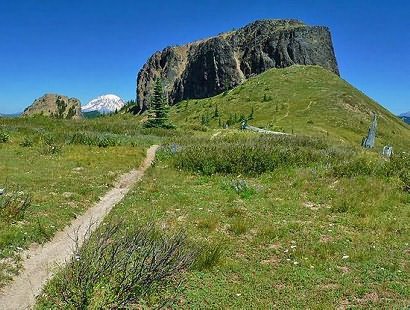
Now, the reason to keep on hiking to the south side
of Jumbo Peak is because it is from this side that
you get the incredible photos of Jumbo. Once you
have your photos, then return to the worn trail
that will take you to the top.
This hike is one of the best of the best, and even
though it is a long drive to get the trail head,
the hike is worth every minute of travel time. And,
do not let the fact that this a motorized trail keep
you from hiking it. It is just too good to miss!!!
|