|
 |
| A PICTURE IS WORTH A THOUSAND WORDS |
MOVE MOUSE OVER MAP CAMERA ICONS  TO VIEW PHOTOS - F5 TO REFRESH TO VIEW PHOTOS - F5 TO REFRESH |
 |
 |
MOVE MOUSE OVER  TO VIEW QUICK-LINK MAP TO VIEW QUICK-LINK MAP
CLICK ON ANY HIKE ICON TO JUMP TO THAT HIKE |
|
|
|
| Hike Length: |
6.5 miles round trip |
| Elev. Change: |
1000' gain |
| Hike Difficulty: |
Moderate |
| Type of Hike: |
Loop options |
| Season: |
Mid-Summer thru Fall |
|
| Trail Numbers: |
#9, 20, 67, 106 |
| Trail Condition: |
Good |
| Trail Access: |
Good |
| Trail Signage: |
Good |
| Features: |
Views, Wildflowers, Mt. Goats |
|
| Pet Friendly: |
Yes |
| Useage: |
Heavy |
| Permit: |
Yakama Nation Pass Required |
| Horses: |
Yes |
| Mtn Bikes: |
No |
|
|
Summary:
Press CTRL + P to print. Photos do not show when you print this page. (Help)

Note: This hike, as well
as Hikes 81, and 94 are all located within the Yakama
Nation. A fee is required by the Yakama Nation to carry on
any activities in this area. By the way, be aware that
the spelling of Yakama was changed from Yakima in 1994.
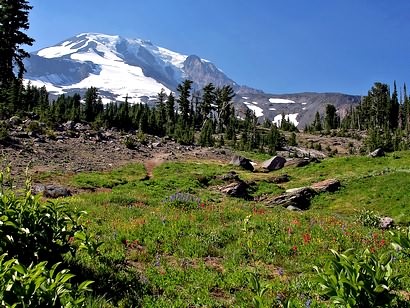
The absolutely best time to hike in the Bird Creek
Meadows area is when the wildflowers are in full
bloom. The challenge is to get there at the exact
time. It is a challenge because the peak of floral
display varies from year to year. However, you
should be in good luck any time from the end of July
through the end of August.
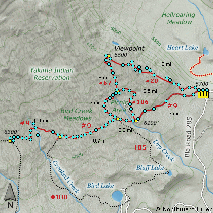
The Bird Creek Meadows hike is really a combination of
several hikes and loops. I recommend heading straight for
the viewpoint overlooking Hell Roaring Canyon first, then
do a variety of loops through the meadows afterward.
The climb up to the viewpoint is a bit steep, but not
very long, so not very difficult. The views along this
route are magnificent. Hike this in the morning and
your photo opportunities are endless. Keep an eye
on the hillsides on the north side of the canyon for
mountain goats.
Once you reach the Overlook, follow the trail that leads
back down to the meadows areas. Keep to the right while
going and then to the left when returning. However, due
to the various loops available, you can select from several
options.

To hike over at least as far as the Crooked Creek junction
will give you the better views and discover the extraordinary
beauty of this magnificent place.
Be sure to respect the guidelines and restrictions that are
in place in this hiking area. Remember, we are guests here,
and need to be grateful to the Yakama Nation for access to
this scenic and floral wonder.
|
|
The following images are random samples of the wildflowers found in the Gifford Pinchot National Forest.
Mouseover image to view flower name, and click on image to jump to flower guide.
|
Directions:
From Portland, OR
From Portland, travel east on Interstate Hwy 84 to Exit 64 at Hood River.
Turn left, and pass under the freeway and cross the toll bridge ($1.00)
into Washington state. Turn left onto SR14 and drive approximately 1.5
miles to state road 141 Alt. Turn right onto SR141 Alt. and follow it another
2 miles and merge bearing left onto SR141. Then travel north on SR141
for another 19 miles to Trout Lake and the junction to Mt. Adams Road,
which heads north to other hike destinations.
from Trout Lake, WA
Bear right and forward onto Mt. Adams Road for about 1.3 miles and you
come to the junction with Forest Road 23.
Bear right and continue on Mt. Adams Road, which is also Forest Road 82,
for another half mile or so, and when you come to Forest Road 80, bear again
to the right and stay on FR82. To reach the Bird Creek Meadows area, just
stay on FR82 for another 8.3 miles past FR80. At this point, FR82 turns
into the Bureau of Indian Affairs Road 285 as well as FR8290.
Continue on BIA285 for another 4.2 miles and you will come to Mirror Lake
and the junction of BIA304 which takes you to Bird Lake. For the trailhead
to Bird Creek Meadows, just continue another mile and the parking area with
trailhead will be on your left.
Click on the link below to see a map taking you to the trailhead.
|
|
|
|
 |
|
|
A Virtual Hike in the Gifford Pinchot National Forest

|

