Search Northern Central Goat Rocks Mt Adams SE Hikes SW Hikes St Helens Hike List Return
Hike 90 Mt. Margaret from Johnston Ridge Main Menu
A PICTURE IS WORTH A THOUSAND WORDS MOVE MOUSE OVER MAP CAMERA ICONS TO VIEW PHOTOS - F5 TO REFRESH
MOVE MOUSE OVER TO VIEW QUICK-LINK MAP
CLICK ON ANY HIKE ICON TO JUMP TO THAT HIKE
Print Topo Map Hike Difficulty
Calculator
 
Legend Ten Essentials  

Hike Length: 16 miles round trip
Elev. Change: 2600' gain
Hike Difficulty: Very Difficult
Type of Hike: In and Out
Season: Mid-Summer thru Fall
Trail Numbers: #1, 1-F
Trail Condition: Good
Trail Access: Excellent
Trail Signage: Good
Features: Views, Wildflowers, Lakes
Pet Friendly: Not Allowed
Useage: Light
Permit: NW FP Required
Horses: No
Mtn Bikes: No

 Volcano Alert    Click Volcanic Alert to discover if there are any current safety concerns.

Summary:
Press CTRL + P to print. Photos do not show when you print this page. (Help)


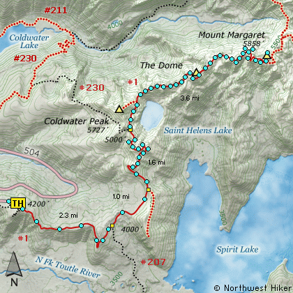
This is a long but rewarding approach to Mount Margaret. The hike begins at the Johnston Observatory on Johnston Ridge. Keep in mind that if you choose to hike from this location, you may need a permit to park in the Observatory parking area.

The hike follows the Boundary trail from the Johnston Ridge Observatory all the way to Mount Margaret. This is the same route to Harry's Ridge, and Coldwater Peak. So, the description is identical up to the point where the Boundary Trail leaves the junction to Coldwater Peak.

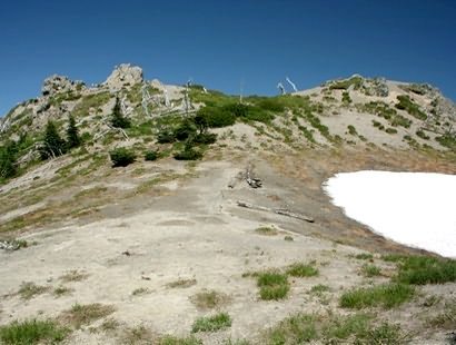
From that junction to Mount Margaret the trail winds its way across the volcanic barren landscape past what is called The Dome. This is a large rock outcropping which is a destination in itself.


As the trail circles to the north of St. Helens Lake, you get great vistas looking back toward Mt. St. Helens and Coldwater Peak. Then eventually, the trail breaks over the ridge so you can see Mt. Whittier and Mt. Rainier rising up behind Mt. Whittier.

In season this trail is surrounded by a great diversity of wildflowers which add to the joy of this adventure. From the summit of Mount Margaret you can see Mt. Rainier to the north, the Goat Rocks to the northeast, Mt. Adams to the east, Mt. Hood to the southeast and Mt. St. Helens directly south, as it rises above Spirit Lake.


The following images are random samples of the wildflowers found in the Gifford Pinchot National Forest.
Mouseover image to view flower name, and click on image to jump to flower guide.

Directions:

From Seattle, WA
Drive south on I-5 to the junction of State Road 504. Exit the freeway, and turn left (east) onto SR504 and follow it east. At five miles you will pass the Silver Lake Visitor Center and in another 38 miles you will come to the junction to SR504 E. Bear right onto SR504 East and follow it another 8 miles to the Johnston Ridge Observatory.
(closed in winter)

From Portland, OR
Drive north on I-5 to the junction of Washington State Road 504. Exit the freeway, and turn right (east) onto SR504 and follow it east. At five miles you will pass the Silver Lake Visitor Center and in another 38 miles you will come to the junction to SR504 E. Bear right onto SR504 East and follow it another 8 miles to the Johnston Ridge Observatory.
(closed in winter)


Click on the link below to see a map taking you to the trailhead.

Map Directions


Vicinity Map


To contact the Gifford Pinchot NF for current information: Click Here.


A Virtual Hike in the Gifford Pinchot National Forest
Click for PDF
Click for PDF