Summary:
Press CTRL + P to print. Photos do not show when you print this page. (Help)
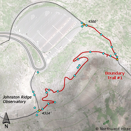
This rather steep universal access trail is a must
do walk while visiting the Johnston Ridge Observatory.
The trail is kinda steep, but paved and an excellent
way to view and learn about the Mt. St. Helens
phenomena. There are guided walks along this part
of the Boundary Trail, which begins at the observatory
and heads east to Mt. Adams.
The following images are random samples of the wildflowers found in the Gifford Pinchot National Forest.
Mouseover image to view flower name, and click on image to jump to flower guide.
From Seattle, WA
Drive south on I-5 to the junction of State Road 504. Exit the freeway, and turn
left (east) onto SR504 and follow it east. At five miles you will pass the Silver Lake
Visitor Center and in another 38 miles you will come to the junction to SR504 E.
Bear right onto SR504 East and follow it another 8 miles to the Johnston Ridge Observatory. (closed in winter)
From Portland, OR
Drive north on I-5 to the junction of Washington State Road 504. Exit the freeway, and turn
right (east) onto SR504 and follow it east. At five miles you will pass the Silver Lake
Visitor Center and in another 38 miles you will come to the junction to SR504 E.
Bear right onto SR504 East and follow it another 8 miles to the Johnston Ridge Observatory. (closed in winter)
Click on the link below to see a map taking you to the trailhead.