
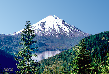
U.S.G.S. Photograph taken before
May 19, 1982, from Harry's Ridge,
Mount St. Helens National Volcanic Monument.
|
Go to Main Menu
|
| Recent Activity |
Please be aware that in the fall of 2004, Mt. St. Helens began to show
a considerable amount of volcanic activity. This activity warrented the
closing of several trails that are on this CD. It is not know how long
the trail closures will be in effect, therefore before attempting to hike
any of the trails on this CD that are near Mt. St. Helens, it would be
very wise to check with the local Forest Service authorities to see if
the trail of your interest is open to hiking activity. You may call this
number for information regarding trail closures: 360-449-7800
| Mt. St. Helens, the story |
(Courtesy of the United States Geology Service)
After remaining dormant for 123 years, a series of small
earthquakes in March 1980 signaled that the magma — hot molten
rock — below the mighty mountain was shifting. In the next two
months, more than 10,000 earthquakes shook the volcano,
including one March 27 that blasted a crater through the
summit’s ice cap. Then, at 8:32 a.m. on May 18, 1980, a
5.1 magnitude earthquake shook the mountain and caused the
summit to slide away, triggering eruptions that reached 80,000
feet in 15 minutes and would last throughout the day. As
the mountain began to blow, David Johnston, a U.S. Geologic
Survey geologist observing the mountain from 5 miles away,
radioed his last words to his colleagues in Vancouver, Wash.:
“Vancouver! Vancouver! This is it!” he screamed. “Vancouver!
Vancouver! Is the transmitter still working?”
The area had been evacuated, but a few defied orders. A
local 83-year-old lodge owner named Harry Truman became a
legend when he refused to leave his home 5 miles away from the
mountain. Truman, along with his 16 cats, pink Cadillac Coupe
de Ville and 38 bottles of Schenley bourbon, was buried within
seconds of the eruption under a 200-foot-deep avalanche.
Rocks, ash, volcanic gas and steam blasted upward and
outward at 300 miles an hour and 660 degrees Fahrenheit. The
blast killed 57 people, wiped out river valleys and destroyed
enough trees to build 300,000 homes. The eruption spewed
520 tons of volcanic ash, causing complete darkness in
Spokane, Wash., 250 miles away. All that remained of the
mountain’s beautiful snow-capped peak was a barren crater
large enough to fit downtown Seattle. Touring the mountain
five days later, President Jimmy Carter said, “It makes the
surface of the moon look like a golf course.”
| Historical Information |
From:
Foxworthy and Hill, 1982, Volcanic Eruptions of 1980 at Mount St. Helens,
The First 100 Days: USGS Professional Paper 1249
Mount St. Helens was known as "the Fuji of America" because its symmetrical beauty was similar to that of the famous Japanese volcano. The graceful cone top, whose glistening cap of perennial snow and ice dazzled the viewer, is now largely gone. On May 18, 1980, the missing mountaintop was transformed in a few hours into the extensive volcanic ash that blanketed much of the Northwestern United States and into various other deposits closer to the mountain.
Even before its recent loss of height, Mount St. Helens was not one of the
highest peaks in the Cascade Range.
Its summit altitude of 9,677 feet made it only the fifth highest peak in
Washington. It stood out handsomely, however, from surrounding hills because it
rose thousands of feet above them and had a perennial cover of ice and snow.
The peak rose more than 5,000 feet above its base, where the lower flanks merge
with adjacent ridges. The mountain is about 6 miles across at its base, which
is at an altitude of about 4,400 feet on the northeastern side and about 4,000
feet elsewhere. At the pre-eruption timberline (upper limit of trees), the
width of the cone was about 4 miles.
Mount St. Helens is 34 miles almost due west of Mount Adams, which is in the eastern part of the Cascade Range. These "sister and brother" volcanic mountains are each about 50 miles from Mount Rainier, the giant of Cascade volcanoes. Mount Hood, the nearest major volcanic peak in Oregon, is about 60 miles southeast of Mount St. Helens.
Mount St. Helens was named for British diplomat Alleyne Fitzherbert (1753-1839), whose title was Baron St. Helens. The mountain was named by Commander George Vancouver and the officers of H.M.S.Discovery while they were surveying the northern Pacific coast from 1792 to 1794.
Mount St. Helens was recognized as a volcano at least as early as 1835; the first geologist apparently viewed the volcano 6 years later. James Dwight Dana of Yale University, while sailing with the Charles Wilkes U.S.Exploring Expedition, saw the peak (then quiescent) from off the mouth of the Columbia River in 1841. Another member of the expedition later described "cellular basaltic lavas" at the mountain's base.
Although Mount St. Helens is in Skamania County, the best access routes to the mountain run through Cowlitz County on the west. State Route 504, ... connects with the heavily traveled Interstate Highway 5, about 34 miles to the west. That major north-south highway skirts the low-lying cities of Castle Rock, Longview, and Kelso along the Cowlitz River and passes through Vancouver, Washington - Portland, Oregon, metropolitan area less than 50 miles to the southwest. The community nearest the volcano is Cougar, which is in the Lewis River valley about 11 miles south-southwest of the peak. Guifford Pinchot National Forest surrounds Mount St. Helens, but some land ... are Washington State lands or are privately owned. ...
Mount St. Helens, like most other Cascade volcanoes, is a great cone of rubble consisting of lava rock interlayered with pyroclastic and other deposits. Volcanic cones of this internal structure are called composite cones or stratovolcanoes. Mount St. Helens includes layers of basalt and andesite through which several domes of dacite lava have erupted. The largest of the dacite domes formed the previous summit; another formed Goat Rocks on the northern flank. ...
| Early Documentation |
USFS Photograph taken before May 18, 1980, by Jim Nieland, U.S. Forest Service, Mount St. Helens National Volcanic Monument. |
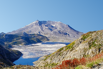
Northwest Hiker Photograph taken September 2003, by Dennis Stilwell |
Before the devastating May 18, 1980 eruption, Mount St. Helens was considered to be one of the most beautiful and most frequently-climbed peaks in the Cascade Range. Spirit Lake was a vacation area offering hiking, camping, boating, and fishing.
From: Pringle, 1993, Roadside Geology of Mount St. Helens National Volcanic Monument and Vicinity: Washington State Department of Natural Resources, Division of Geology and Earth Resources Information Circular 88
The first documented observation of Mount St. Helens by Europeans was by George Vancouver on May 19, 1792, as he was charting the inlets of Puget Sound at Point Lawton, near present-day Seattle. Vancouver did not name the mountain until October 20, 1792, when it came into view as his ship passed the mouth of the Columbia River.
A few years later, Mount St. Helens experienced a major eruption. Explorers, traders, missionaries, and ethnologists heard reports of the event from various peoples, including the Sanpoil Indians of eastern Washington and a Spokane chief who told of the effects of ash fallout. Later studies determined that the eruption occurred in 1800.
The Lewis and Clark expedition sighted the mountain from the Columbia River in 1805 and 1806 but reported no eruptive events or evidence of recent volcanism. However, their graphic descriptions of the quicksand and channel conditions at the mouth of the Sandy River near Portland, Oregon, suggest that Mount Hood had erupted within a couple decades prior to their arrival.
Meredith Gairdner, a physician at Fort Vancouver, wrote of darkness and haze during possible eruptive activity at Mount St. Helens in 1831 and 1835. He reported seeing what he called lava flows, although it is more likely he would have seen mudflows or perhaps small pyroclastic flows of incandescent rocks.
On November 22, 1842, Reverend Josiah Parrish, while in Champoeg, Oregon, (about
80 miles or 130 kilometers south-southwest of the volcano), witnessed Mount St.
Helens in eruption. Ash fallout from this event evidently reached The Dalles,
Oregon (48 miles or 80 kilometers southeast of the volcano). Missionaries at
The Dalles corroborated Parrish's account. Captain J.C. Fremont recounts the
report of a clergyman named Brewer, who gave him a sample of ash a year later
(Wilkes, 1845):
"On the 23rd day of the preceding November, St. Helens had scattered its ashes, like a light fall of snow, over the Dalles of the Columbia."
Other accounts of the same ashfall note that it was "like fine sand", its color "appeared like ashes", and the odor was "that of sulphur" (Majors, 1980).
Contemporary sketches and paintings by Paul Kane suggest the mountain was probably erupting at a point halfway down the north slope before or during 1847. The vent was apparently the Goat Rocks dome, which was removed by the 1980 eruption. On the basis of these and other observations, scientists think eruptive activity may have continued intermittently until 1857.
Small eruptions were reported in 1898, 1903, and 1921, but these events were not independently confirmed, nor have their deposits been identified. Judging by the nature of the post-May 18, 1980, activity at Mount St. Helens, it is likely that these events were steam emissions, small explosions, or large rockfalls.
|
Go to Main Menu
|