Introduction
The United States Congress designated the Goat Rocks Wilderness in 1964
and it now has a total of 108,096 acres. All of this wilderness is located in
Washington and is managed by the Forest Service.
Description
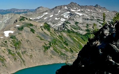 The Goat Rocks Wilderness is a portion of the volcanic Cascade Mountain Range
in southwestern Washington located between Mt. Rainier and Mt. Adams. The Goat
Rocks are remnants of a large volcano, extinct for some two million years.
Glaciation and erosion have worn away at the terrain here, leaving moderate
summits on both sides of the crest of the Cascades. The elevation in the Goat
Rocks ranges from 3,000 feet to 8,201 feet at Gilbert Peak. The deep east-west
drainages below the ridges often open into park-like alpine meadows dotted with
small lakes and even smaller ponds.
The Goat Rocks Wilderness is a portion of the volcanic Cascade Mountain Range
in southwestern Washington located between Mt. Rainier and Mt. Adams. The Goat
Rocks are remnants of a large volcano, extinct for some two million years.
Glaciation and erosion have worn away at the terrain here, leaving moderate
summits on both sides of the crest of the Cascades. The elevation in the Goat
Rocks ranges from 3,000 feet to 8,201 feet at Gilbert Peak. The deep east-west
drainages below the ridges often open into park-like alpine meadows dotted with
small lakes and even smaller ponds.
Annual snowfall typically equals more than 25 feet, not melting entirely until
late July or early August and keeping the ponds and lakes full when it does give
in to the sun. Pikas and marmots scurry about above timberline, while the more
reserved deer and elk have been spotted lower down. Mountain goats frequently
show up in the higher country.
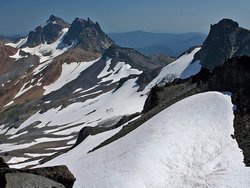
Much of the 120-mile trail system stays on the ridges at or above timberline.
The Pacific Crest National Scenic Trail (PCT) wanders north-south through the
middle of the Wilderness for 31.1 miles, past 7,930-foot Old Snowy Mountain,
where glaciers persist. Approximately 14 other trails climb to eventually join the PCT.

A 105,600-acre alpine wonderland, the Goat Rocks Wilderness is a portion of
the volcanic Cascade Mountain Range in southwestern Washington between Mount Rainier
and Mount Adams. The Goat Rocks are remnants of a large volcano, extinct for some
two million years. This ancient volcano once towered over the landscape at more
than 12,000 feet in elevation, but has since eroded into several peaks averaging
around 8,000 feet. The cluster of rocks and peaks have become known as Goat Rocks
because of the bands of mountain goats that live here.
Goat Rocks Wilderness features mountainous terrain with elevations from 3,000
feet to 8,201 feet on Gilbert Peak. Much of it lies above timberline, providing
out-standing alpine scenery. Many high-elevation trails remain impassable, due
to snow, until July and snow can return as early as September.
The wilderness values of this area have long been recognized. On February 13,
1931, approximately 44,500 acres were officially dedicated by the U.S. Department
of Agriculture, Forest Service, as the Goat Rocks Primitive Area. In 1935, this
was expanded to 72,440 acres. In 1940, the area was increased to 82,680 acres
and designated the Goat Rocks Wild Area by the Chief of the Forest Service.
When Congress passed the Wilderness Act on September 3, 1964, this Wild Area
became a Wilderness, part of the National Wilderness Preservation System. Congress
added additional acreage in 1984. Forest Service management is designated to preserve
and enhance the wild character of the Wilderness while providing for public use
and enjoyment.
The Pacific Crest National Scenic Trail (PCNST), stretching from Canada to
Mexico, passes through the Goat Rocks. The Washington State portion of this trail
was formerly known as the Washington Cascade Crest Trail completed in 1935. In
1968, it was designated as part of the PCNST by the National Trail System Act.
The Yakama Indian Reservation, bordering the Goat rocks Wilderness on the southeast
side, is closed to the general public except for the Pacific Crest National Scenic
Trail route.
Permits
Remember, Wilderness Permits are required when you enter any wilderness area in the Gifford Pinchot National Forest.
Click Here for more information.
Rules
Click Here for PDF on Restrictions
Gifford Pinchot
Oh, by the way, who was Gifford Pinchot?
Click Here for more information.

