Introduction
The United States Congress designated the Tatoosh Wilderness in
1984 and it now has a total of 15,725 acres. All of this wilderness
is located in Washington and is managed by the Forest Service.
The Tatoosh Wilderness is bordered by the Mount Rainier Wilderness to the north.
Description
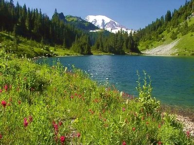 One of five Wilderness areas near Mount Rainier National Park, the Tatoosh
Wilderness Area shares a portion of the park's southern boundary. Tatoosh
Ridge, a long, formidably rugged ridge, runs north-south out of the park to
cross the Wilderness near the middle. On the eastern side of the area you'll
find the southern end of another rocky spine, Backbone Ridge, which also hails
from the park. Numerous streams cascade off the ridges into the Muddy Fork
of the Cowlitz River or into Butter Creek, both of which funnel down to the
Cowlitz River south of the Wilderness. Deer and elk winter along the Muddy Fork,
then wander into the higher country in warmer seasons. Black bears may be seen
foraging in the forest of hemlock, fir, and red cedar, and mountain goats scramble
along the upper elevations, which top out at 6,310-foot Tatoosh Lookout.
About 25 feet of snow falls on Tatoosh Ridge during the winter, dusting a
half-dozen small lakes (including three that thoroughly satisfy the meaning of "tiny").
One of five Wilderness areas near Mount Rainier National Park, the Tatoosh
Wilderness Area shares a portion of the park's southern boundary. Tatoosh
Ridge, a long, formidably rugged ridge, runs north-south out of the park to
cross the Wilderness near the middle. On the eastern side of the area you'll
find the southern end of another rocky spine, Backbone Ridge, which also hails
from the park. Numerous streams cascade off the ridges into the Muddy Fork
of the Cowlitz River or into Butter Creek, both of which funnel down to the
Cowlitz River south of the Wilderness. Deer and elk winter along the Muddy Fork,
then wander into the higher country in warmer seasons. Black bears may be seen
foraging in the forest of hemlock, fir, and red cedar, and mountain goats scramble
along the upper elevations, which top out at 6,310-foot Tatoosh Lookout.
About 25 feet of snow falls on Tatoosh Ridge during the winter, dusting a
half-dozen small lakes (including three that thoroughly satisfy the meaning of "tiny").
The 8.6-mile Tatoosh Trail climbs wickedly steep up Tatoosh Ridge but then mellows
out substantially for a long descent off the ridge top and down through subalpine
meadows abounding with summer wildflowers. The view of Mount Rainier to the north
is breathtaking. Side trails will take you to Tatoosh Lakes and historic site of the
Tatoosh Lookout. Camping or fires are not allowed beside the fragile wilderness
lakes within the Tatoosh Lakes Basin.
The 15,700-acre Tatoosh Wilderness is bounded on the north by Mount Rainier
National Park. It is steep and rugged with subalpine and alpine areas along
the ridgeline. The area also contains 550 acres of the Butter Creek Natural
Area. Tatoosh Wilderness includes a variety of physical features, from river bottoms
to subalpine ridge tops.
The Tatoosh Wilderness is a relatively recent additions to the Wilderness system.
It was officially designated as Wilderness by Congress in 1984.
This area was added to the Wilderness system to protect and preserve the scenic,
alpine environments and to compliment the adjacent Mount Rainier National Park,
most of which is also designated as Wilderness.

Tatoosh Ridge (6,310 feet) provides excellent views in all directions and is
the former site of a fire lookout built in 1932. This particular lookout gained
notoriety after the book "Tatoosh" was published. The author, Martha
Hardy, wrote about her experiences keeping watch at the Tatoosh fire lookout.
The Tatoosh Range was used historically by Taidnapam (Upper Cowlitz) Indians.
In mid-to-late August, Taidnapam families would climb up the ridge from fishing
camps at the confluence of the Muddy Fork and Clear Fork Cowlitz Rivers, to hunt,
gather materials for making baskets, and pick huckleberries for drying.
The dried berries were transported to home villages for eating during the winter
months. Archaeological evidence suggests that these high country treks were a
long tradition among the local Indian people.
Jim Yoke, a Taidnapam elder interviewed in 1926-1927 by anthropologist Melville
Jacobs said this about Tatoosh: "He (Coyote) thought of a mountain, he named
it neq'u't* ("breast", Tatoosh). At that place, he determined there
would be lots of berries, that people would climb up it, gather those berries,
dry them, and descend again to the same place where they were drying fish."
*neq'u't approximate pronunciation: nuk-koot
Permits
Remember, Wilderness Permits are required when you enter any wilderness area in the Gifford Pinchot National Forest.
Click Here for more information.
Rules
Click Here for PDF on Restrictions
Gifford Pinchot
Oh, by the way, who was Gifford Pinchot?
Click Here for more information.

