


|
THE FOLLOWING MAPS ARE NOT TO BE USED FOR NAVIGATIONAL PURPOSES.
 View the slideshow for more sequential photos of this hike.
|
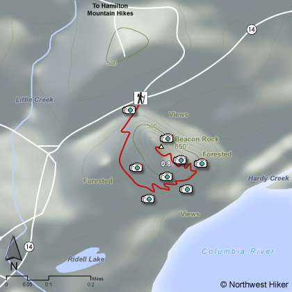
Length: 1.6
miles round trip
Elevation Change: 750' gain
Season: Year
Round
Difficulty: Moderate due to steep climb
Permit: As of the summer of 2006, no fee required
Features: 
This is one of the more interesting hikes located within the
Columbia River Gorge. This rock sticking up out of the
banks of the Columbia River has a trail built into the
side of it like no other trail you may have ever hiked.
The hike is short but steep. Mr. Biddle, who built the
trail, went to great effort to make a way for the average
person to get to the top of Beacon Rock. He built bridges
and steps and thus made it possible for folks like us
these many years later to enjoy the uniqueness of this hike.
The gate is only open during certain hours, so be sure to
take note when you begin as to when the gate will be closed.
 This hike provides fantastic views of the Columbia River
Gorge, and even has wildflowers along the way during spring
and summer. From the top of Beacon Rock, one gets exhilerating
views of Hamilton Mountain to the northeast and Bonneville Dam
to the east.
This hike provides fantastic views of the Columbia River
Gorge, and even has wildflowers along the way during spring
and summer. From the top of Beacon Rock, one gets exhilerating
views of Hamilton Mountain to the northeast and Bonneville Dam
to the east.
Use caution and common sense while climbing this steep trail,
and this can be an excellent hike for the whole family.
|
|
The following images are random samples of the wildflowers found in the Columbia River Gorge National Scenic Area.
Mouseover image to view flower name, and click on image to jump to flower guide.
|
Directions:
From Portland, OR
From Portland, travel east on Interstate Hwy 84 to Exit
Click on the link below to see a map taking you to the trailhead.
|
|
|
|
 |


