


|
THE FOLLOWING MAPS ARE NOT TO BE USED FOR NAVIGATIONAL PURPOSES.
 View the slideshow for more sequential photos of this hike.
|
Length: 9.4 mile loop
Elevation Change: from 360' to 2445'
Season: Year Round, even in the snow, BUT use Extreme Caution
Difficulty: Challenging due to steepness of trail and length of hike
Permit: As of the summer of 2006, no fee required
Features: 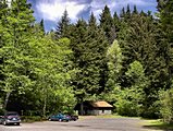
An outstanding hike with all the right features such as water falls,
steep cliffy areas, superb views, ridge line hiking, and deep
forested areas, complete with a loop for minimal repeat
scenery. When Beacon Rock State Park is open, you drive to the
picnic area and park at the Hamilton Mountain trailhead. When the
park is closed, leave your car along side the road by Beacon Rock.
 The hike begins moderately steep for about a mile then becomes more gentle as
you approach the first of two falls. Hardy Falls is visible by taking
a short side trip, but Rodney Falls is fully visible as your cross
Hardy Creek on a bridge right at the foot of the falls. At this point
the trail becomes much steeper and for the next 2 plus miles you gain
nearly 1800' in elevation. About 2.5 miles into the hike you come to
a junction where the trail returns via a loop from the back side of
Hamilton Mountain.
The hike begins moderately steep for about a mile then becomes more gentle as
you approach the first of two falls. Hardy Falls is visible by taking
a short side trip, but Rodney Falls is fully visible as your cross
Hardy Creek on a bridge right at the foot of the falls. At this point
the trail becomes much steeper and for the next 2 plus miles you gain
nearly 1800' in elevation. About 2.5 miles into the hike you come to
a junction where the trail returns via a loop from the back side of
Hamilton Mountain.
 If you continue straight ahead, you will come to the
base of the Little Hamilton Mountain. The works its way around to the west
side of the slope and begins a very vigorous climb through a series of
small switchbacks. At about 3 miles you level out on a little saddle between
Little Hamilton and the main Hamilton Mountain. By now you are feasting
on incredible vistas of the Columbia River Gorge and Beacon Rock. As you
climb higher and higher, you will begin to see more of the mountains of
Oregon to the south of you.
If you continue straight ahead, you will come to the
base of the Little Hamilton Mountain. The works its way around to the west
side of the slope and begins a very vigorous climb through a series of
small switchbacks. At about 3 miles you level out on a little saddle between
Little Hamilton and the main Hamilton Mountain. By now you are feasting
on incredible vistas of the Columbia River Gorge and Beacon Rock. As you
climb higher and higher, you will begin to see more of the mountains of
Oregon to the south of you.
 Finally, you reach the top of Hamilton, and
at the junction there, take the path to the right to a rest area with a view.
Return by walking the ridge line to the north for about a mile while continuing
to enjoy extremely delightful views of Table Mountain to the northeast,
and Mt Hood to the southeast. The trail eventually hooks up with a service
road which you will follow for about a mile before entering back into the
dense forested areas. This loop will conclude at the junction you saw on
the way up the mountain at about the 2.5 mile mark.
Finally, you reach the top of Hamilton, and
at the junction there, take the path to the right to a rest area with a view.
Return by walking the ridge line to the north for about a mile while continuing
to enjoy extremely delightful views of Table Mountain to the northeast,
and Mt Hood to the southeast. The trail eventually hooks up with a service
road which you will follow for about a mile before entering back into the
dense forested areas. This loop will conclude at the junction you saw on
the way up the mountain at about the 2.5 mile mark.
|
|
The following images are random samples of the wildflowers found in the Columbia River Gorge National Scenic Area.
Mouseover image to view flower name, and click on image to jump to flower guide.
|
Directions:
From Portland, OR
From Portland, travel east on Interstate Hwy 84 to Exit
Click on the link below to see a map taking you to the trailhead.
|
|
|
|
 |


