


|
THE FOLLOWING MAPS ARE NOT TO BE USED FOR NAVIGATIONAL PURPOSES.
 View the slideshow for more sequential photos of this hike.
|
Length: .6 mile round trip up Gorge, 1.5 miles round trip to bridge
Elevation Change: 400' gain
Season: Year Round
Difficulty: Easy
Permit: No Pass Required
Features:
This popular adventure up Oneonta Gorge is extremely unique. You can visit Oneonta
Gorge any time of year, but you dare only hike up it when the water is very low,
because UNLIKE ANY OTHER HIKE ON THIS CD, you must actually walk up the river, there
is no trail.... the river is the trail.
 You park in the designated areas near the Oneonta Bridge, and walk down to the water
on the east side of the bridge. After that, you're on your own. Seems precarious,
but it shouldn't be.... thousands do it every year.... and they all survive. Almost
immediately you will come to a large log jam stuck in the canyon. Be VERY CAREFUL
when crossing this, especially if any of it is wet, because it can be very slippery.
After you get across the log jam, now you just walk up the creek.... I mean wade....
in other words.... YOU GET WET.
You park in the designated areas near the Oneonta Bridge, and walk down to the water
on the east side of the bridge. After that, you're on your own. Seems precarious,
but it shouldn't be.... thousands do it every year.... and they all survive. Almost
immediately you will come to a large log jam stuck in the canyon. Be VERY CAREFUL
when crossing this, especially if any of it is wet, because it can be very slippery.
After you get across the log jam, now you just walk up the creek.... I mean wade....
in other words.... YOU GET WET.
This is a very short hike, but very soon you are up to your you know what is water.
Yes, it gets deep, and for children, they may not be the ticket, especially for small
children. The water at its lowest is probably about 3 feet deep, so we aren't talking
over anyones head.... unless anyone is very short. Anyway, after wading this pond,
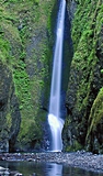
you come to the end, and the reward that makes it all worth it.... the falls.
 After you've taken all the film that's left in your camera, you now have to repeat this
process by wading back out of this hole.... oops, I mean gorge. On a hot summer's day,
hiking doesn't get much better than this. When you finally get back to your vehicle,
and you get dried off and you get dry shoes on your feet, if you'd like, you might
want to go for another short hike and see the top of that canyon you just waddled up.
After you've taken all the film that's left in your camera, you now have to repeat this
process by wading back out of this hole.... oops, I mean gorge. On a hot summer's day,
hiking doesn't get much better than this. When you finally get back to your vehicle,
and you get dried off and you get dry shoes on your feet, if you'd like, you might
want to go for another short hike and see the top of that canyon you just waddled up.
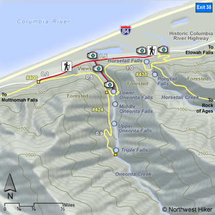
Just walk west of Oneonta about a 1/4 mile and you will come to the trail to Triple
Falls. Take this trail for about anther 1/4 mile and you will connect to the Gorge 400
trail. Follow this trail back toward Triple Falls for another 1/2 mile and you will
come to the junction of the trail to Pony Falls and Horse show Falls. Follow this trail
down into the canyon just a bit and you will come to a fantastic bridge spanning the
Oneonta Gorge just above the falls where you were just wading.
Upstream above the bridge is another nice falls on Oneonta Creek that you can enjoy
right from the bridge.
|
|
The following images are random samples of the wildflowers found in the Columbia River Gorge National Scenic Area.
Mouseover image to view flower name, and click on image to jump to flower guide.
|
Directions:
From Portland, OR
From Portland, travel east on Interstate Hwy 84 to Exit
Click on the link below to see a map taking you to the trailhead.
|
|
|
|
 |


