

|
About Northwest Hiker
|


|
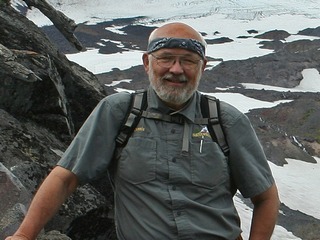 My name is Dennis Stilwell. I was
adopted by a family who moved me from my birth state of Wisconsin to the Pacific
Northwest when I was only three, placing me in the middle of some of the most
beautiful landscape on earth. At the young age of six I talked my neighbor friend
into climbing a mountain just a mile from where we lived. Of course the mountain
was only a hill, but you get the idea. I was born to hike. It's in my blood.
Only the constraints of life of a business manager keep me off the trail.
My name is Dennis Stilwell. I was
adopted by a family who moved me from my birth state of Wisconsin to the Pacific
Northwest when I was only three, placing me in the middle of some of the most
beautiful landscape on earth. At the young age of six I talked my neighbor friend
into climbing a mountain just a mile from where we lived. Of course the mountain
was only a hill, but you get the idea. I was born to hike. It's in my blood.
Only the constraints of life of a business manager keep me off the trail.
In February of 2000, I decided to create a web site that would bring to one place
all the useful information that a hiker might need for planning an outdoor adventure.
I not only wanted trail information, but weather, road conditions, and where
possible, web-cams to show us what the weather is like at a place close to a
hiker's area of interest. Then I decided to put photos of hikes on the web site.
I have always felt that a picture is worth a 1000 words, and I found lots of
web sites with lots of words, but very few pictures.
Then, because of the 9/11/01 event in our country, I found myself unemployed
and with too much time on my hands. So I decided to create Virtual Hike CDs.
The CDs were developed to make "the next best thing to being there" a reality.
Often a hiker contemplates a particular hike but is a bit reluctant to try it because
the hiker is unfamiliar with the trail details. If the hiker hasn't heard someone talk
about it or hasn't read much about it, there is a reluctance to try something new.
This is particularly true if there is considerable distance to drive to the trail head.
The Virtual Hike CDs are a solution to this dilemma. By viewing the slide presentation of
a hike, a person can make an informed decision regarding whether or not they want to
actually do the hike. The thousands of photos presented on these CDs were taken personally
by me and are presented in the order that the hike unfolds.
 The maps and narrative are to give the user perspective. I hired a professional cartographer,
Adam Wilbert, Cartogaia.com to create the maps.
They give a close representation of where the trail is in
relationship to roads, rivers, mountains, and such. The distances I use between trail
markers were determined from other sources as well as the data I recorded while hiking
the trail myself.
The maps and narrative are to give the user perspective. I hired a professional cartographer,
Adam Wilbert, Cartogaia.com to create the maps.
They give a close representation of where the trail is in
relationship to roads, rivers, mountains, and such. The distances I use between trail
markers were determined from other sources as well as the data I recorded while hiking
the trail myself.
I have prepared the CDs in such a way as to not only make them informative but also to
make them entertaining. To sit back an view any of the hike slide shows with a musical selection
playing in the background is truly an enjoyable experience. There are over seven hours of
viewing in all 85 slide shows.
One of the features that most of my customers just love is the Screen saver. Ironically,
I never intended to offer a screen saver because I knew that my camera was not capable of
taking truly professional pictures. But my son talked me into it and what do know,
people just love it. This newest CD has a 100 photo screen saver covering most of the different
hikes on the CD.
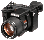
Now just a brief word about the cameras I used to take the thousands of photos on my
Virtual Hike CDs. I started out with a 1.2 mega pixel Olympus Camera. I took over 35,000
photos with that camera before it finally succumbed to the constant abuse of trail travel.
Then I purchased the Panasonic DMC-FZ20 with 5.3 mega pixels. I choose these cameras because
of the extraordinary optical telephoto lens. The Olympus has a 10 power optical lens and
the Panasonic has a 12 power optical lens. Both have outstanding Macro options.
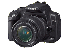
Next I added the digital SLR to my options by purchasing the Canon 350D. This is an
eight mexa pixel camera, and I purchased three lenses for it. It came with an 18-55mm
lens, and I purchased a 28-135mm lens as well as a Tamron 28-300. About half of my
new photos were taken with the wide angle lens and half with the 28-135mm. I rarely
use the Tamron. Here is a picture of the three cameras:
Olympus E100RS
|
Panasonic DMC-FZ20
|
Canon 350D
|
Karl Maloszek of Berlin, Germany provided the panoramic technology that is on
this CD.
Applet courtesy of Simple Software
|

|

|
|
|