Summary:
Press CTRL + P to print. Photos do not show when you print this page. (Help)
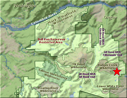
 There are several creek hikes available in the Badger Creek Wilderness area, but this hike comes
with its own historic log cabin (although it is not in the best of shape) and an old abandoned mine.
So, I chose to include this creek hike to add variety to your hiking options and another dry place
to hike, just in case it is raining on the west side of the Hood.
There are several creek hikes available in the Badger Creek Wilderness area, but this hike comes
with its own historic log cabin (although it is not in the best of shape) and an old abandoned mine.
So, I chose to include this creek hike to add variety to your hiking options and another dry place
to hike, just in case it is raining on the west side of the Hood.
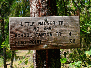
This hike is just a few miles from the Ball Point / School Canyon Trail hike, and the trail actually
connects to the School Canyon Trail. I haven't learned why they call it the School Canyon Trail, seeing
that the vast majority of the trail is not in any canyon but mostly along a ridge top. Anyway, the
Little Badger Creek trail takes you four miles up the creek that gives it its name, and then connects
to the School Canyon trail, which climbs steeply out of the Badger Creek Canyon and actually goes all
the way to Flag Point.
There is ample parking across the road from the trailhead, and the trail is well-signed. For the first
mile and a half the trail keeps pretty close to the creek, and on a hot summer day this is a very
refreshing quality. However, then the trail climbs away from the creek up the north side of the canyon
and out of the deep forest and shade of the valley below. It is my understanding that the trail used to
follow pretty closely to the creek, and even crossed back and forth from one side to the other as it made
its way upstream. Not anymore. After about a mile and a half the trail climbs away from the creek and never
actually gets next to it again.
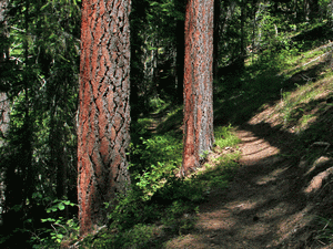
There has been a forest fire in recent years so from time to time you will hike through a burn
area which of course distracts from the beauty of the surroundings. However, there are plenty
of beautiful delicious smelling Ponderosa Pines along the way. These unusual trees start life
out as any normal dark barked conifer, but after they reach the age of 110 to 120 years, they shed their
dark bark and reveal the yellow-orange colored bark beneath. Also, if you get up close and
personal with one of these mature Ponderosa, and put your nose near one of the surface cracks,
you will enjoy the pleasant smell of butterscotch or vanilla. Scientists do not know why this
species does this, but we get the joy of walking amongst these beautiful trees and on a warm
summer day we get to enjoy the wonderful fragrance they emit.
The trail climbs in and out of side gullies and through open grassy areas as well as Oregon White
Oak forests. In season there are plenty of wildflowers to enjoy and birds to identify. Near the
end of the four miles, the trail drops down near the creek and you arrive at the broken down remains
of some person's dream. The name is Kinzel. It seems as though they hoped to find wealth in the
earth by digging copper out of it. Even though the mine tunnel is only about eighty feet long, it
must have been pretty hard work searching for the treasure they didn't seem to find. The photo shows
how narrow the tunnel is and its unusual color. The mine tunnel is "J" shaped. It appears to be
safe to enter, but I must be safe too, and I do not recommend that you enter this mine tunnel for
any reason whatsoever, unless it is to satisfy your curiosity. (sorry, I couldn't help myself)
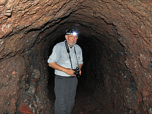 The mine is located just a short distance beyond the old cabin via the trail that takes you to the
School Canyon Trail. I didn't see any sign to indicate that you had arrived at that trail, but it
breaks off the trail to the mine and climbs steeply up out of the canyon. To see the mine, just
continue on straight ahead a few more feet and it is plainly visible.
The mine is located just a short distance beyond the old cabin via the trail that takes you to the
School Canyon Trail. I didn't see any sign to indicate that you had arrived at that trail, but it
breaks off the trail to the mine and climbs steeply up out of the canyon. To see the mine, just
continue on straight ahead a few more feet and it is plainly visible.
Oh, I did run into a herd of cattle on this hike, so I am assuming that there is open range here.
Watch where you step!
|