Summary:
Press CTRL + P to print. Photos do not show when you print this page. (Help)
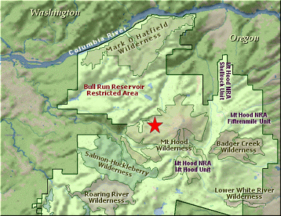
 Ramona Falls may be the most popular hike in the Mt Hood National Forest.
The loop hike is a great option in that it offers more variety.
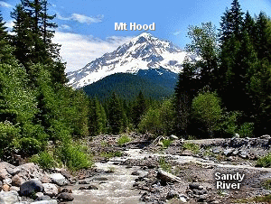
After you leave the parking lot at the trailhead, the trail wanders along the Sandy
River for nearly a mile before offering you the opportunity to cross the almost
always muddy and swift water. Occassionally, the trail gets close enough to the
river for views, but most of the time it is in the forest.
Ramona Falls may be the most popular hike in the Mt Hood National Forest.
The loop hike is a great option in that it offers more variety.
After you leave the parking lot at the trailhead, the trail wanders along the Sandy
River for nearly a mile before offering you the opportunity to cross the almost
always muddy and swift water. Occassionally, the trail gets close enough to the
river for views, but most of the time it is in the forest.
This entire area is susceptible to floor damage nearly every year. So, be prepare
for things to be different that hiking guides such as this one portray them.
After crossing the river on the bridge supplied by the Forest Service, you will
come to an intersection where the loop trail returns. Again, like all loop trails,
you have the option of which way to complete the loop.
This description will follow the trail counterclockwise, which means continue on straight ahead instead of turning
to the left.
The trail parallels the Sandy River, but only rarely gives you a glimpse of it. However,
from season to season and from year to year this also changes dramatically. So, you may
have views of the river or at least the damage left behind from winter flooding.
You also begin to gain elevation. In season this part of the hike is lush and green with
lots of Rhododendrons. At about the 2.8 mile mark you will come to the junction of
the Pacific Crest Trail #2000 and the cutoff trail to the falls. Bear left at this
point and walk about a half mile to the falls. Be very careful to stay on the trail
at the falls due to the very fragile environment.
 After you take all the photos you can afford, cross the little wooden bridge to begin
you journey back. Immediately, you will face the intersection of the trail to Yocum
Ridge and the route back to your car. Bear left, and follow this quaint little trail
along the little stream that formed Ramona Falls. As you hike along this trail you
will have many opportunities to enjoy little waterfalls and cascades, and lots of
flowers in the right season.
After you take all the photos you can afford, cross the little wooden bridge to begin
you journey back. Immediately, you will face the intersection of the trail to Yocum
Ridge and the route back to your car. Bear left, and follow this quaint little trail
along the little stream that formed Ramona Falls. As you hike along this trail you
will have many opportunities to enjoy little waterfalls and cascades, and lots of
flowers in the right season.
When you come to the intersection of Trail #784, bear to the left again, and you
will complete the loop part of Trail #797 after crossing the little stream that
created Ramona Falls. From this point, just follow the trail back across the
Sandy River and on to the parking lot and trailhead where you began the hike.
Also, Click Here for useful suggestions on river crossings.
|