Summary:
Press CTRL + P to print. Photos do not show when you print this page. (Help)
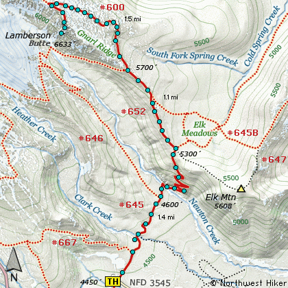
 The hike up Gnarl Ridge to Lamberson Butte is a real gem. The hike
begins near the Mt Hood Meadows Sno Park area and travels level for nearly the first
mile. The most difficult part of the hike is crossing Newton Creek. The water is
fast and depending on the time of year or current weather conditions, the water can
vary greatly in depth. Use caution crossing. After reaching the north side of the
creek, the trail climbs vigorously for about a half mile through a series of 9 switchbacks.
At the top of the ridge, the trail intersects the trail to Bluegrass Ridge and Gnarl Ridge.
If you continue straight ahead, you will come to Elk Meadows. However, follow Trail #646
on your left up Gnarl Ridge toward Mt Hood.
The hike up Gnarl Ridge to Lamberson Butte is a real gem. The hike
begins near the Mt Hood Meadows Sno Park area and travels level for nearly the first
mile. The most difficult part of the hike is crossing Newton Creek. The water is
fast and depending on the time of year or current weather conditions, the water can
vary greatly in depth. Use caution crossing. After reaching the north side of the
creek, the trail climbs vigorously for about a half mile through a series of 9 switchbacks.
At the top of the ridge, the trail intersects the trail to Bluegrass Ridge and Gnarl Ridge.
If you continue straight ahead, you will come to Elk Meadows. However, follow Trail #646
on your left up Gnarl Ridge toward Mt Hood.
 In a little over a half mile you will pass the intersection of Trail #652A which also leads
to Elk Meadows. Continuing on you will come to the Timberline Trail #600 which will lead
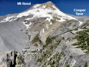
to Lamberson Butte. In about a mile and a half the trail opens up on a ridge at the base
of Lamberson Butte. At that point, one must scramble up the northwest side of the butte to
reach the top. The view is as good as it gets and the cliff off Lamberson Butte down to
Newton Creek is very impressive. Use Caution.
In a little over a half mile you will pass the intersection of Trail #652A which also leads
to Elk Meadows. Continuing on you will come to the Timberline Trail #600 which will lead
to Lamberson Butte. In about a mile and a half the trail opens up on a ridge at the base
of Lamberson Butte. At that point, one must scramble up the northwest side of the butte to
reach the top. The view is as good as it gets and the cliff off Lamberson Butte down to
Newton Creek is very impressive. Use Caution.
Also, Click Here for useful suggestions on river crossings.
|