Summary:
Press CTRL + P to print. Photos do not show when you print this page. (Help)
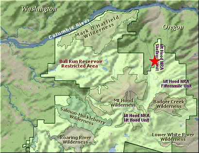
 This hike is a little different, in that it isn't entirely within the national
forest, or wilderness areas, and it starts on a road and crosses a road a number
of times. This hike takes you up Oak Ridge to the Surveyor's Ridge Trail, which
is a favorite of mountain bikers. One outstanding feature about mountain bike trails
is that the bikers keep the trail extremely well groomed. Thank them when you get
an opportunity.
This hike is a little different, in that it isn't entirely within the national
forest, or wilderness areas, and it starts on a road and crosses a road a number
of times. This hike takes you up Oak Ridge to the Surveyor's Ridge Trail, which
is a favorite of mountain bikers. One outstanding feature about mountain bike trails
is that the bikers keep the trail extremely well groomed. Thank them when you get
an opportunity.
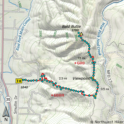
You begin the climb on Trail #688A, which starts out fairly gentle, but then climbs
steeply until you reach the top and the Surveyor's Ridge Trail #688. As you leave
the trail head you can see your destination, Bald Butte, in the distance with a set
of very large power lines running between you and the summit. Also, within a quarter
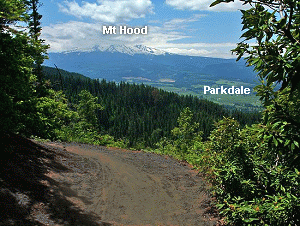
mile, you will skirt a recently logged clear cut area. The upside is that you now
get fantastic views of Mt Hood, and soon the clear cut will be awash in wildflowers.
 Shortly after the logged area, the trail descends briefly to cross a small stream, then
begins to climb. Soon you will cross a fairly new logging road, and after you do, the
trail really begins to climb. From here on it gains about 850 feet per mile, all the
way to the top of the ridge. Very few areas are gentle, but there are some, and the
wildflowers are abundant both in the dense forested areas and out in the open areas.
Shortly after the logged area, the trail descends briefly to cross a small stream, then
begins to climb. Soon you will cross a fairly new logging road, and after you do, the
trail really begins to climb. From here on it gains about 850 feet per mile, all the
way to the top of the ridge. Very few areas are gentle, but there are some, and the
wildflowers are abundant both in the dense forested areas and out in the open areas.
Just before you reach the Surveyor's Ridge Trail, you will cross yet another logging road.
Actually, you could take the road by bearing to the left and walking a short distance
to the place where Trail 688 crosses this road, then pick up the trail heading north
from there. Or, you could cross the road where you meet it, and walk a very short
distance to Trail #688, then bear left, or north, and head for Bald Butte.
 After leaving that road area, the trail meanders gently north, then as it makes a short
sharp descent, you will come out into an open area with a fantastic view of Mt. Hood
to the south. Continue north on the trail, skirting yet another logged area, you will
descend to the power line area. You can actually drive to this part of the trail, if
you only want to take the short steep climb up Bald Butte. Either way, the trail now
resembles more of a road than a trail as it makes its way up a very steep knoll. The
top of this knoll is tree covered, but the ascent offers fantastic views to the south.
After leaving that road area, the trail meanders gently north, then as it makes a short
sharp descent, you will come out into an open area with a fantastic view of Mt. Hood
to the south. Continue north on the trail, skirting yet another logged area, you will
descend to the power line area. You can actually drive to this part of the trail, if
you only want to take the short steep climb up Bald Butte. Either way, the trail now
resembles more of a road than a trail as it makes its way up a very steep knoll. The
top of this knoll is tree covered, but the ascent offers fantastic views to the south.
The road/trail wanders through a forested area before descending rather steeply to a
saddle. Then you are at the very base of Bald Butte. The climb up the face is fairly
steep, but short and the rewards when you reach the top make all of this so rewarding!
In season the wildflowers are abundant, and in the winter the snowfields are adrift.
Anyway or anytime you choose to climb Bald Butte, you are in for a treat.
Enjoy!
|