Summary:
Press CTRL + P to print. Photos do not show when you print this page. (Help)
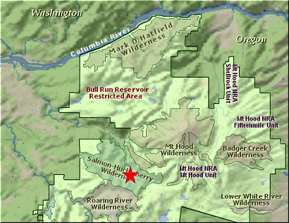
 This is one of those delightful hikes with little popularity. It climbs pretty steeply,
so I call it Difficult, but it is a great hike. Located in the heart of the Salmon-Huckleberry
Wilderness, Salmon Butte offers outstanding views and lots of spring and summer flowers.
This is one of those delightful hikes with little popularity. It climbs pretty steeply,
so I call it Difficult, but it is a great hike. Located in the heart of the Salmon-Huckleberry
Wilderness, Salmon Butte offers outstanding views and lots of spring and summer flowers.
The trailhead parking area is a simple little pullout on Forest Road #2618. The trailhead
is not well marked. You used to drive up a little dirt road to the trailhead, but they
placed a berm there, so now you park on the forest road and hike in the additional few
hundred feet. The locals have not been kind to this area, but don't let that discourage
you. This hike is worth it.
Just as you begin the hike, you will come to the forest service sign in booth. Then
you're on your way. The trail wanders through an old forest with large cedars and
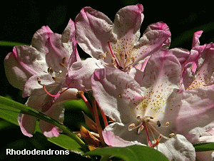
hemlocks. As you climb the trail is often lined with the ever present Rhododendrons.
In season they are beautiful and add much to the enjoyment of this hike. From time
to time there are breaks in the dense forest and you get opportunities to enjoy the
vistas.
 The steep climb is broken up by several switchbacks which make the grade tolerable.
The greenery that lines that trail makes it look surreal at times. About 3.5 miles
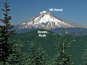
into the climb you will change over to the eastern side of the ridge. Here you
will be treated to great vistas of not only Mt Hood, but Devil's Peak, and the
Salmon River valley below you. At about 4 miles the trail gets fairly steep for
just a short distance and you come to the junction of the old service road that
approaches from the south. Bear to the right and follow this road, turned trail,
around the north side of the butte to the west side where you approach the top.
The steep climb is broken up by several switchbacks which make the grade tolerable.
The greenery that lines that trail makes it look surreal at times. About 3.5 miles
into the climb you will change over to the eastern side of the ridge. Here you
will be treated to great vistas of not only Mt Hood, but Devil's Peak, and the
Salmon River valley below you. At about 4 miles the trail gets fairly steep for
just a short distance and you come to the junction of the old service road that
approaches from the south. Bear to the right and follow this road, turned trail,
around the north side of the butte to the west side where you approach the top.
The reward is here on top. Views abound and the reward is great. Enjoy.
|