Summary:
Press CTRL + P to print. Photos do not show when you print this page. (Help)
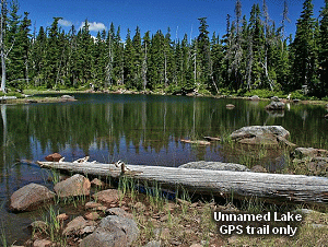
 This is the only hike that I include on this CD that we used a GPS to find
the small unnamed lakes that have no trails to them. To find the many small
ponds and lakes within the trail circle indicated on the above map, one must
have a GPS system that has a reliable topo map in it. If on the other hand,
you don't have a GPS, or choose not to venture out in unmarked territory,
this hike is still a fantastic adventure. If you just stay on the main
trails and even include Fish Lake, the whole loop, including
the walk back on the road, is less than 8 miles.
This is the only hike that I include on this CD that we used a GPS to find
the small unnamed lakes that have no trails to them. To find the many small
ponds and lakes within the trail circle indicated on the above map, one must
have a GPS system that has a reliable topo map in it. If on the other hand,
you don't have a GPS, or choose not to venture out in unmarked territory,
this hike is still a fantastic adventure. If you just stay on the main
trails and even include Fish Lake, the whole loop, including
the walk back on the road, is less than 8 miles.
I began the hike at the Lower Lake trailhead, and hiked the loop counterclockwise.
The entire trail is in very good condition and there are no significant streams
or such obstacles to endure. Hiking along Trail #717, it is only a mere half mile hike to Lower Lake. The
trail skirts the east and north side of the lake. Then you come to a junction
with Trail #706.
 It is at this point you can either bear left onto Trail #706 and continue the loop
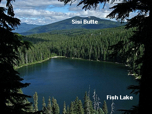
around this lake basin, or you can continue following Trail #717 another .7 mile to Fish Lake.
Even if you only hike to the overlook where you can see Fish Lake below and Sisi Butte
in the distance. Then return to the junction of Trail #706 and head west about another
mile to Middle Lake. It was here that we got out our GPS unit and bushwhacked our way
to a number of the smaller lakes within the loop.
It is at this point you can either bear left onto Trail #706 and continue the loop
around this lake basin, or you can continue following Trail #717 another .7 mile to Fish Lake.
Even if you only hike to the overlook where you can see Fish Lake below and Sisi Butte
in the distance. Then return to the junction of Trail #706 and head west about another
mile to Middle Lake. It was here that we got out our GPS unit and bushwhacked our way
to a number of the smaller lakes within the loop.
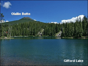
Finley Lake and Gifford Lakes are outstanding small lakes. But then, as you can see by
the mouse-over images on the above map, many of the smaller unnamed lakes are well worth
the effort to reach. Do not attempt hiking to these lakes if you do not have experience
following GPS navigation from way point to way point. Much of the areas between these small
lakes is densely forested and quite brushy in places. And there are cliffs hidden within
the forest that could easily get you in trouble.
After we explored the various lakes we made our way back to Middle Lake and picked up
Trail #706 and continued west to the junction with Trail #719 near Fork Lake. It is less
than a half mile to Sheep Lake if you'd like to take the time to explore to the west. You
could climb Potato Butte while you are there (see Hike 88). Whatever you decide, make
your way back the junction of Trails #706 and #719 and head southeast on Trail #719.
 The trail climbs for the next half mile or so and levels out at a small pond, before heading
back downhill to the junction with the Pacific Crest Trail. When you reach the PCT, bear
to the left and head east back toward Forest Road 4220. Soon the trail is following a ridge
which allows you great views to the southeast and south toward Mt. Jefferson. About a mile
along this part of the trail we used our GPS to give us a bearing on our vehicle which we
left at the Lower Lake Trailhead.
The trail climbs for the next half mile or so and levels out at a small pond, before heading
back downhill to the junction with the Pacific Crest Trail. When you reach the PCT, bear
to the left and head east back toward Forest Road 4220. Soon the trail is following a ridge
which allows you great views to the southeast and south toward Mt. Jefferson. About a mile
along this part of the trail we used our GPS to give us a bearing on our vehicle which we
left at the Lower Lake Trailhead.
So, we chose to go off trail and bushwhack our way past several more small unnamed lakes to
the trailhead where we began this adventure. Again, be absolutely sure you know what you
are doing if you also choose this option. There is a significant cliff along the way that
you will have to negotiate, but other than that, it is just very brushy.
Or, you can just continue along the PCT to Forest Road 4220 and walk the road back to the
Lower Lake trailhead where you began. This is one of many beautiful lake basins nestled in the
forests of the Olallie Lake Scenic Area .
|