Summary:
Press CTRL + P to print. Photos do not show when you print this page. (Help)
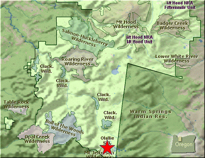
 This hike is like the cream of the crop. A fantastic little stroll through the
Olallie Lake Scenic Area . Vistas and Lakes galore and good trails.... what more can a hiker ask?
I did throw in Double Peaks just to add a little difficulty to the hike, but that's
optional.
This hike is like the cream of the crop. A fantastic little stroll through the
Olallie Lake Scenic Area . Vistas and Lakes galore and good trails.... what more can a hiker ask?
I did throw in Double Peaks just to add a little difficulty to the hike, but that's
optional.
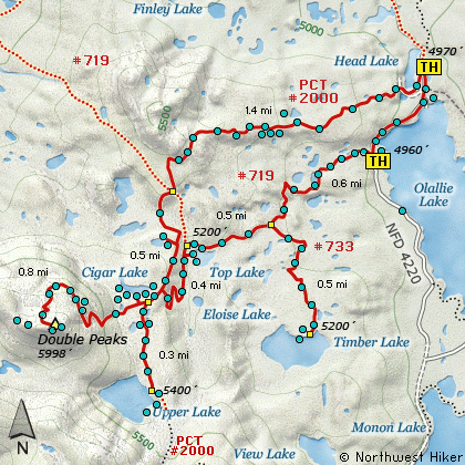
I started the hike where the Pacific Crest Trail #2000 crosses Forest Road #4220 just
before the junction to the Olallie Lake Resort. Immediately, you get to enjoy one of the
many beautiful lakes on this hike. As you pass Head Lake the trail climbs a bit into
a fairly open area. From time to time you are in more dense tree growth and then back
out into the open. At about a half mile you'll get your first spectacular views of
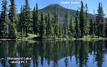
Mt Jefferson to the south. Behind you all this time is the incredible Olallie Butte.
At about a mile and a half you come to the intersection of the Red Lake Trail #719 and
the PCT #2000. Keep straight ahead on #2000 which will take you past a small alpine
lake just off the trail a bit. You'll see where others have walked to the lake for
great photo ops of the lake and of Double Peaks. Back on the trail, and you will walk
just a short distance and you will come to the junction of the trail down to Top Lake.
Bear right at this point and continue to Cigar Lake.
 If you'd like to climb Double Peaks, keep your eye open for the cutoff trail which will
leave your trail to the right just a bit past the Cigar Lake sign. There was a cairn and
a post the day I hiked it, but who knows what the future holds. The trail is pretty
obvious, so leave the PCT #2000 and follow this trail past Cigar Lake and to Double Peaks.
You'll know you've got the right trail if your trail was built by the same people that
build the trail up Potato Butte.... no such thing as switchbacks.
If you'd like to climb Double Peaks, keep your eye open for the cutoff trail which will
leave your trail to the right just a bit past the Cigar Lake sign. There was a cairn and
a post the day I hiked it, but who knows what the future holds. The trail is pretty
obvious, so leave the PCT #2000 and follow this trail past Cigar Lake and to Double Peaks.
You'll know you've got the right trail if your trail was built by the same people that
build the trail up Potato Butte.... no such thing as switchbacks.
Yup, the trail just climbs and climbs... very steep. But not for very long. Soon the
trail wanders off to the right a bit and isn't quite so steep. In a short distance
you will start enjoying spectacular views of Mt Hood to the north and Olallie Butte
to the east and all the beautiful lakes below. The trail continues up. You'll enter
a more heavily forested area on the north side of Double Peaks, and then you'll begin
the last extremely steep climb.
This part of the climb is not dangerous but it is so very steep. Again, it's not for very
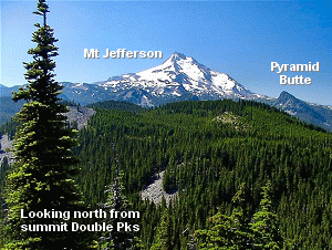
long, and you've reached the top. Bear to the right for a few feet and you'll get all
the views you could want to the south, west, and north. Walk back to the saddle and
continue on a hundred feet or so to the east, and you'll be blessed with excellent views
to the east and the south, and all the lakes in between. The climb up here is worth it.
Now, back down the mountain to the PCT #2000. Bear to the right for about a third of
a mile and you will come to the very beautiful Upper Lake. This short jaunt is more
than worth it. This lake is just plain gorgeous. Now, backtrack to Cigar Lake and
that junction down to Top Lake.
 In less than a half mile you'll come to Top Lake. Leave the trail and walk over to the
lake for spectacular views and photo ops. You can walk along the lake to your left, or
north, and you'll come back to the trail. At the north end of the lake is a junction.
Take the trail to your right, or around the north side of the lake. Follow this trail for
about a half mile and you will come to the junction of the Timber Lake Trail.
In less than a half mile you'll come to Top Lake. Leave the trail and walk over to the
lake for spectacular views and photo ops. You can walk along the lake to your left, or
north, and you'll come back to the trail. At the north end of the lake is a junction.
Take the trail to your right, or around the north side of the lake. Follow this trail for
about a half mile and you will come to the junction of the Timber Lake Trail.
Its only about a half mile to Timber Lake and more than worth the time and effort. This
is a rather large lake and is located in a beautiful setting. Drink up the beauty and
in season the flowers. Retrace your path back to the trail from Top Lake. Bear right,
away from Top Lake, east, and follow this trail to the Forest Road 4220 that you are
parked on. You will need to walk the road back to your vehicle. It is about a quarter
mile or so. As you walk back, you will be treated to grand views of Mt Jefferson and
Olallie Lake.
|