Mt. Jefferson Wilderness
| (HOME) | (RETURN) |
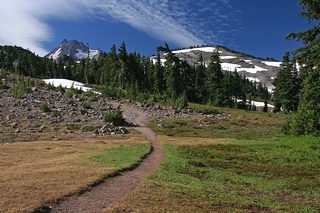 Mt. Jefferson from Park Ridge trail |
 Mt. Jefferson from Park Ridge |
|
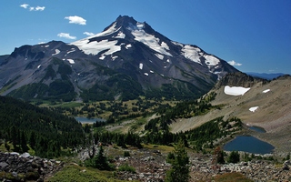
Introduction The United States Congress designated the Mount Jefferson Wilderness in 1968 and it now has a total of 107,008 acres. All of the wilderness is in Oregon and is managed by the Forest Service. Description Even though only a small portion of the Mt. Jefferson Wilderness is in the Mt. Hood National Forest (and that portion is administrated by the Willamette National Forest), I felt it was appropriate to mention it and include a hike from within it, because the wilderness borders the Mt. Hood NF at the Olallie Butte Recreational Area. Five glaciers mantle the slopes of stately Mount Jefferson, the dominant feature in this region of the High Cascades: Whitewater, Waldo, Milk Creek, Russell, and Jefferson Park. At 10,497 feet, Mount Jefferson challenges hikers with the steepest, most difficult climb of Oregon's high summits. The southern portion of the area rests beneath 7,841-foot Three Fingered Jack. Most of the high country of this Wilderness is wide open, almost like a park, with scattered tree cover, long talus slopes, rocky outcroppings, alpine meadows, and year-round patches of snow. Between 5,000 feet and 6,000 feet you'll find more than 150 small lakes, about half of them stocked with trout. A grand forest of Douglas fir, silver fir, subalpine fir, mountain hemlock, lodgepole pine, ponderosa pine, and cedar mix with vine maple, huckleberry, and rhododendron to distinguish the lower elevations. The vast Warm Springs Indian Reservation shares a long northeastern border. Hikers can wend their way through approximately 190 miles of very heavily used trails, including about 40 miles of the Pacific Crest National Scenic Trail. Jefferson Lake, Marion Lake, Pamelia Lake, and Jack Lake are the most impacted by human traffic. Permits Remember, Wilderness Permits are required when you enter any wilderness area in the Mt. Hood or Willamette National Forests. Click Here for more information. (Courtesy of the USFS) |