Opal Creek Wilderness
| (HOME) | (RETURN) |
 Opal Creek above the bridge |
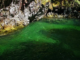 Opal Creek pool that gives it a name |
|
Introduction The United States Congress designated the Opal Creek Wilderness in 1996 and it now has a total of 20,733 acres. All of the wilderness is in Oregon and is managed by the Forest Service. Description Even though the Opal Creek Wilderness is NOT in the Mt. Hood National Forest, I felt it was appropriate to mention it and include a hike from within it, because the wilderness borders the Mt. Hood NF and the Bull of the Woods Wilderness. Opal Creek Wilderness features steep and rugged forested hillsides. The eastern portion of the area encompasses the headwaters of two major creeks (Battle Axe Creek and Opal Creek) which join to become the Little North Santiam River. The western portion of the area is dominated by two prominent peaks; Whetstone and Henline Mountains, which offer scenic vantage points and were once used as fire lookout sites. Opal Creek Wilderness can be reached via Oregon State Highway 22 and Marion County North Fork Road. The county road becomes Forest Road 2209 at the forest boundary. This road parallels the boundary of the western portion of the wilderness. Three trailheads, Henline Falls-Ogle Mountain, Henline Mountain and Nasty Rock trails are along the road. The eastern or "interior" portion of the wilderness is reached from the gated end of road 2209. Public vehicle traffic is not permitted beyond the gate but foot, and horse travel is allowed. This former mining access route continues to parallel the wilderness boundary and trailheads for Whetstone Mountain, Mike Kopetski-Opal Creek and Battle Axe Creek trails are located along the route. (Bicycles are allowed on the road beyond the gate into Jawbone Flats but are prohibited on trails off of the road.) Permits Remember, Wilderness Permits are required when you enter any wilderness area in the Willamette National Forest. Click Here for more information. (Courtesy of the USFS) |