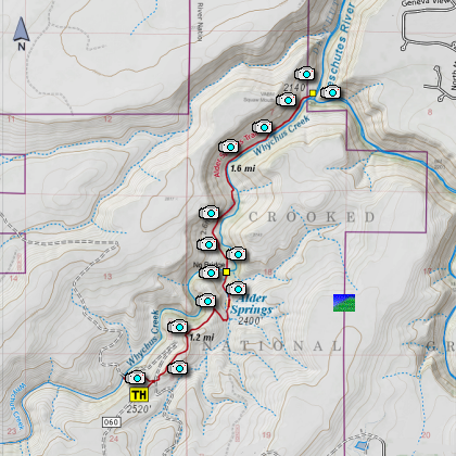
Length: 6 miles round trip
Elevation Change: 650' elevation gain
Season: Spring thru Fall
Difficulty: Challenging (due to creek crossing)
Permit: NW Forest Pass not Required
Features:
Alder Springs trail is a popular Central Oregon hike located about 17 miles NE of Sisters.
The trail starts on a high desert ridge, drops into a spectacular canyon at the Alder Springs
oasis, continues along peaceful Whychus Creek and culminates at a dramatic bolder-strewn
rapids of the Deschutes river.
There was an old ranch house that was used as a meth lab near the current
location of the trailhead parking area. After a police raid in the 1990s, the property
was seized by authorities, the house demolished and the Alder Springs hiking trail built
along with a parking area, but no restroom. The trailhead is well marked
at the North end of the parking area.
The Alder Springs trail begins on a dry, sparsely vegetated ridge and then descends
1.4 miles (450 ft elevation loss) to Alder Springs in the Whychus Creek Canyon.
If the confluence of Whychus Creek with the Deschutes River is the goal, a wet stream
crossing over Whychus creek is necessary. Sandals or water shoes and trekking poles
are advisable because of knee-deep water with a swift current and uneven rocky stream
bottom. Early snowmelt or rain storms may render the creek unsafe to cross. After
crossing Whychus Creek, the trail continues another 1.6 miles to a rock outcrop
adjacent to raging rapids at the confluence of Whychus Creek and the Deschutes River.
Striking geology is one of the remarkable features of this area. The walls of the canyon
reveal colorful layers of volcanic tuff, basalt and conglomerate deposits like horizontal
stacks of library books. Monoliths resembling giant chess pieces are perched precariously
along the canyon walls.
The sparse vegetation in the area (consisting primarily of ponderosa pines, juniper trees,
alder trees, bitterbrush, grasses and wild flowers) was significantly impacted by a fire
in 2011. However, grasses and wildflowers are once again growing in the area. Some of
the isolated trees along the canyon walls and many of the alders in the canyon floor
survived the fire.
Due to the fragile environment in this area, this is a hiker only trail. Hikers should
stay on the trails and dog owners are asked to keep their pets on a leash and bring a
plastic bag to carry out dog waste. The area is closed from December 1 to March 31 to
protect soil and wildlife.
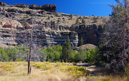
View from Whychus Creek of canyon walls
|