Summary:
Press CTRL + P to print. Photos do not show when you print this page. (Help)
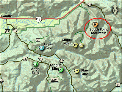
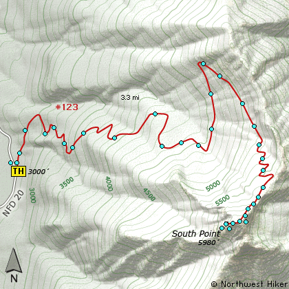
This hike begins on Forest Road #20. Keep in mind
that this hike climbs nearly 3000' in about 3 miles.
Therefore, the trail begins its steep ascent
immediately. Almost all of this hike is in dense
forest.
Much of the trail actually follows old logging
roads as it makes its way up South Point Mountain.
Not until about 2.5 miles and 2000' of elevation
do you get any respectable views. At that point
you also get great floral displays in season.
Over the next mile you get to climb the last
1000 feet and it is not until the end that you
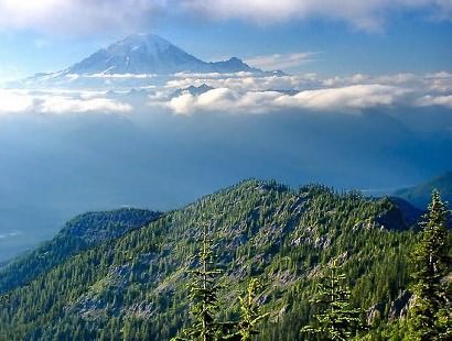
get your reward. And what a reward you get!
This mountain is so steep and the top is so
precarious that it is almost like being in
an airplane. Be aware that you might encounter
snow, even in late July. I didn't make it
the last 300 feet because of the snow. The
snow was hard and very very steep, so I didn't
climb it to the top.
But I did get a photo of a life time, so it
was worth it.
The following images are random samples of the wildflowers found in the Gifford Pinchot National Forest.
Mouseover image to view flower name, and click on image to jump to flower guide.
From I-5 junction with US Hwy 12
Travel east on US Hwy 12 for about 48 miles to Randle.
From Randle travel east on US Hwy 12 for about 12.5 miles to the junction with
Forest Road 20. Turn right (south) onto FR20 and follow it uphill for about 4.3 miles.
At this point you will see a road continuing straight ahead, but stay on FR20 and
follow it to the left over the creek and about a half mile further, and you will
see the trailhead for this hike on your left.
Click on the link below to see a map taking you to the trailhead.