Summary:
Press CTRL + P to print. Photos do not show when you print this page. (Help)
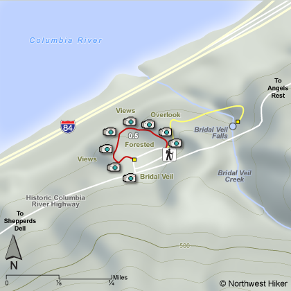
This hike follows a loop trail that takes the visitor to a
number of scenic overlooks of the Columbia River. The path is
paved and is nearly level. In the spring the Camas Root with its
blue flower covers this area with exceptional beauty.
The Oregon State Parks website states:
The upper trail takes visitors around the precipice of the
cliffs of the Gorge. Sign boards along the trail point out
distinctive native wild plants that grow abundantly in this
area such as camas, lupine, bead lilly, trillium and bleeding
heart. The trail is fenced beautifully with logged beams and
wire to protect visitors along the viewpoint while maximizing
every vantage point of the magnificent view of the Gorge. The
famous geologic edifice known as the Pillars of Hercules,
a 120-foot basalt tower once used as a training site for
rock climbing, can be seen best from the upper trail at Bridal Veil.
The lower trail at Bridal Veil takes the visitor downhill to the
base of Bridal Veil Falls and is about a mile round trip to the
falls and back.
The following images are random samples of the wildflowers found in the Columbia River Gorge National Scenic Area.
Mouseover image to view flower name, and click on image to jump to flower guide.


 The lower trail at Bridal Veil takes the visitor downhill to the
base of Bridal Veil Falls and is about a mile round trip to the
falls and back.
The lower trail at Bridal Veil takes the visitor downhill to the
base of Bridal Veil Falls and is about a mile round trip to the
falls and back.


