Summary:
Press CTRL + P to print. Photos do not show when you print this page. (Help)

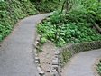
The hike to the top of Multnomah Falls is probably the most hiked
trail in the gorge. The trail begins just to the east of the
beautiful Multnomah Falls lodge, and begins as a paved trail.
Note that there is a gate on the trail that states it closes
at dusk, so be sure to return by then.
The hike to the top of Multnomah Falls is actually quite
challenging. It is amazing how many people do it and
how they are not equiped to do so. I've seen ladies in
high heels do this hike. But I sure would not recommend
it. Actually, you should be sure to have proper footwear
and plenty of liquid to drink.
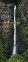
 The trail takes you past an excellent viewing area, and
then climbs up to the extraordinary bridge that crosses
Multnomah Creek between the lower and upper falls. A few
years back, a large stone fell off the face of the cliff
over which Multnomah Falls drops, and burst like a bomb
into the pool at the bottom of the main falls. This could
have been deadly, so they have fenced off the area so that
no one can get there just in case such an event occurs again.
The trail takes you past an excellent viewing area, and
then climbs up to the extraordinary bridge that crosses
Multnomah Creek between the lower and upper falls. A few
years back, a large stone fell off the face of the cliff
over which Multnomah Falls drops, and burst like a bomb
into the pool at the bottom of the main falls. This could
have been deadly, so they have fenced off the area so that
no one can get there just in case such an event occurs again.
 The trail climbs steeply through a series of well designed
switchbacks and brings you to a ridge over which you must
desend. Shortly after this ridge, a cutoff trail to your
right will take you down to the top of Multnomah Falls.
There is a fine viewing deck here and it is very safe if
you abide by the rules and common sense.
The trail climbs steeply through a series of well designed
switchbacks and brings you to a ridge over which you must
desend. Shortly after this ridge, a cutoff trail to your
right will take you down to the top of Multnomah Falls.
There is a fine viewing deck here and it is very safe if
you abide by the rules and common sense.

|
|


