THE FOLLOWING MAPS ARE NOT TO BE USED FOR NAVIGATIONAL PURPOSES.
View the slideshow for more sequential photos of this hike.
Length: 3 miles RT Elevation Change: 405' gain Season: Year Round Difficulty: Easy Permit: NW Forest Pass Required Features:
This hike begins at the same location as the Nesmith Point hike, and
the Ehowah Falls hike. Follow Trail #400 along an abondoned roadbed for a
short distance then as you begin a steep incline you will come to a junction
in the trail. Bear right at this junction and watch out for the poison oak.
Follow the trail uphill through a forested
area toward McCord Creek Falls. After a number of small switchbacks, you will come
out into the open where you begin to enjoy a number of great vistas.
Not only do you have a great view of the Columbia River Gorge, but you can also see the top of Mt Adams
peeking over the northeastern horizon. The trail is cut into the sheer rock wall of this
canyon and has railings for safety. You will be able to view Elowah Falls from the top
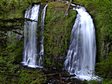
on this trail just before entering a wooded area and coming to McCord Creek Falls. This
double falls is a rare beauty and well worth the hike.
The Columbia River Gorge is full of surprises and this is a special surprise.
The double falls look of this beautiful falls makes it one of the best falls
to visit. In late summer, McCord Creek does get low enough that sometimes
there is only one of the two falls with water in it.
The following images are random samples of the wildflowers found in the Columbia River Gorge National Scenic Area.
Mouseover image to view flower name, and click on image to jump to flower guide.


 View the slideshow for more sequential photos of this hike.


 Not only do you have a great view of the Columbia River Gorge, but you can also see the top of Mt Adams
peeking over the northeastern horizon. The trail is cut into the sheer rock wall of this
canyon and has railings for safety. You will be able to view Elowah Falls from the top
on this trail just before entering a wooded area and coming to McCord Creek Falls. This
double falls is a rare beauty and well worth the hike.
Not only do you have a great view of the Columbia River Gorge, but you can also see the top of Mt Adams
peeking over the northeastern horizon. The trail is cut into the sheer rock wall of this
canyon and has railings for safety. You will be able to view Elowah Falls from the top
on this trail just before entering a wooded area and coming to McCord Creek Falls. This
double falls is a rare beauty and well worth the hike.
 The Columbia River Gorge is full of surprises and this is a special surprise.
The double falls look of this beautiful falls makes it one of the best falls
to visit. In late summer, McCord Creek does get low enough that sometimes
there is only one of the two falls with water in it.
The Columbia River Gorge is full of surprises and this is a special surprise.
The double falls look of this beautiful falls makes it one of the best falls
to visit. In late summer, McCord Creek does get low enough that sometimes
there is only one of the two falls with water in it.


