


|
THE FOLLOWING MAPS ARE NOT TO BE USED FOR NAVIGATIONAL PURPOSES.
 View the slideshow for more sequential photos of this hike.
|
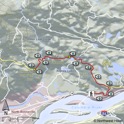
Length: 8
miles round trip
Elevation Change: 600' gain
Season: Year Round
Difficulty: Moderate due to length of hike
Permit: NW Forest Pass Required
Features: 
A great
hike that is available nearly every day of the year. There are
times when the gorge is iced-in and none of the hikes are available,
but for the most part, one can hike this trail any time.
Beginning at the Bonneville Dam trailhead, the hike heads east to
hookup with the popular Pacific Crest Trail.
Following this
trail north the hike brings you to Gillette Lake, which is one of
many lakes formed by the incredible geological event that created
the Bridge of the Gods. The north half of Table Mountain and
of Greenleaf Mountain fell into the gorge, creating the Bridge of
the Gods, and also creating opportunities for many small lakes to
form.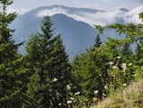
After passing Gillette Lake, you cross a number of
streams and pass another lake on your way to Greenleaf
Overlook. This point is a good destination in that you have a
good view of the Columbia River
Gorge and the surrounding features.
One can continue on this trail, which is the Pacific Crest Trail,
all the way to Table Mountain. But I recommend the Aldrich Butte
approach to Table Mountain.
|
|
The following images are random samples of the wildflowers found in the Columbia River Gorge National Scenic Area.
Mouseover image to view flower name, and click on image to jump to flower guide.
|
Directions:
From Portland, OR
From Portland, travel east on Interstate Hwy 84 to Exit
Click on the link below to see a map taking you to the trailhead.
|
|
|
|
 |


