


|
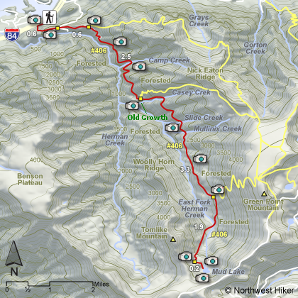
THE FOLLOWING MAPS ARE NOT TO BE USED FOR NAVIGATIONAL PURPOSES.
 View the slideshow for more sequential photos of this hike.
|
Length: 17.8 miles round trip
Elevation Change: 3400' gain
Season: Early Summer thru Fall
Difficulty: Very Difficult due to length
Permit: NW Forest Pass Required
Features: 
This long hike up Herman Creek to Mud Lake is not for everyone, but it is a rewarding
adventure. Remember, you don't have to hike the whole thing. Go as far as you feel
able, and then turn back. Don't take on more than you should.
However much of this hike you choose to endure, the rewards are plentiful. Of course,
different seasons offer different rewards, but spring and summer are a delight. Herman
Creek trailhead is the beginning of many outstanding hikes in the Gorge area, and this
one has its own set of rewards.
 After passing the Gordon Creek cutoff trail and the Nick Eaton Ridge cutoff trails, this
hike up Herman Creek takes on an atmosphere of its own. As you slowly climb high above
Herman Creek, you will pass through Oak forests, with some open areas of floral display.
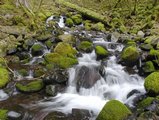
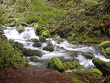
Then after you enter the Hatfield Wilderness, you begin to encounter streams of various
sizes and challenges. Many of the streams have colorful waterfalls for your pleasure.
Some just have lots of water and you may be challenged to get across. The later in the
season you hike this trail, the less likely you are to have to worry about water.
After passing the Gordon Creek cutoff trail and the Nick Eaton Ridge cutoff trails, this
hike up Herman Creek takes on an atmosphere of its own. As you slowly climb high above
Herman Creek, you will pass through Oak forests, with some open areas of floral display.
Then after you enter the Hatfield Wilderness, you begin to encounter streams of various
sizes and challenges. Many of the streams have colorful waterfalls for your pleasure.
Some just have lots of water and you may be challenged to get across. The later in the
season you hike this trail, the less likely you are to have to worry about water.
 On the other hand, drinking water can be a problem. On a hike this long, no matter the
season, take plenty of drinking water. At about 4 miles you will come to the Casey
Creek cutoff trail and a nice camp area. There is a short steep trail off to your right
that will take you down towards Herman Creek and through one of the largest stands of
Old Growth Forests left in the Columbia River Gorge... but maybe that should be another
hike on another day??? So, shortly past this campsite you will cross Casey Creek
and continue your gentile climb towards Mud Lake.
On the other hand, drinking water can be a problem. On a hike this long, no matter the
season, take plenty of drinking water. At about 4 miles you will come to the Casey
Creek cutoff trail and a nice camp area. There is a short steep trail off to your right
that will take you down towards Herman Creek and through one of the largest stands of
Old Growth Forests left in the Columbia River Gorge... but maybe that should be another
hike on another day??? So, shortly past this campsite you will cross Casey Creek
and continue your gentile climb towards Mud Lake.
At about 7 miles is the intersection of Trail #410, which could provide you with an
alternate route back, if you feel up to climbing another 1500' and following Nick Eaton
Ridge back to the Gordon Creek cutoff trail that you encountered earlier on this hike.
However, if you still possess your sanity, you may continue uphill towards Mud Lake.
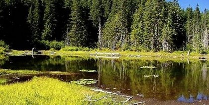
About another 2 miles, after a short steep climb, you will see the Mud Lake sign nailed
to a tree on your left, and at that point is it but a short downhill walk to the lake.
Once again, it depends on the season you choose to do this journey as to the condition
of the lake. It is in its prime in mid to late summer. I feel the rewarding views
and the challenge are a fine reward. Enjoy!
|
|
|
The following images are random samples of the wildflowers found in the Columbia River Gorge National Scenic Area.
Mouseover image to view flower name, and click on image to jump to flower guide.
|
Directions:
From Portland, OR
From Portland, travel east on Interstate Hwy 84 to Exit
Click on the link below to see a map taking you to the trailhead.
|
|
|
|
 |


