THE FOLLOWING MAPS ARE NOT TO BE USED FOR NAVIGATIONAL PURPOSES.
View the slideshow for more sequential photos of this hike.
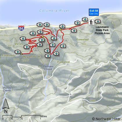
Length: 8
miles round trip loop Elevation Change: 2000' gain Season: Early Spring thru Early Winter Difficulty: Challenging due to elevation gain and length of hike Permit: No Pass Required Features:
Beginning at Lausmann State Park, this hike
is a nice forested hike with an occasional view of the gorge from
various outcroppings along the way. In the spring this hike has
many beautiful floral displays and small streams to enjoy.
The hike starts out following the remains of the old Columbia River
highway built back in 1918. The trail follows the new interstate
freeway for about a mile. Eventually, the trail climbs away from
the freeway and its noise, and you get a greater appreciation of
this hike. In the spring the floral displays are great, but be
aware. There is alot of poison oak along this trail.
After a mile or so, the trail begins to climb in ernest. You
go through several switchbacks and will intersect the trail
that takes you to the top of Wygant Peak. Upon your return, it
is more fun to follow the return loop back to your original
approach than just return the way you came.
The summit is a bit disappointing in
that it is located in dense forest with no view.
The following images are random samples of the wildflowers found in the Columbia River Gorge National Scenic Area.
Mouseover image to view flower name, and click on image to jump to flower guide.


 View the slideshow for more sequential photos of this hike.


 After a mile or so, the trail begins to climb in ernest. You
go through several switchbacks and will intersect the trail
that takes you to the top of Wygant Peak. Upon your return, it
is more fun to follow the return loop back to your original
approach than just return the way you came.
After a mile or so, the trail begins to climb in ernest. You
go through several switchbacks and will intersect the trail
that takes you to the top of Wygant Peak. Upon your return, it
is more fun to follow the return loop back to your original
approach than just return the way you came.


