


|
THE FOLLOWING MAPS ARE NOT TO BE USED FOR NAVIGATIONAL PURPOSES.
 View the slideshow for more sequential photos of this hike.
|
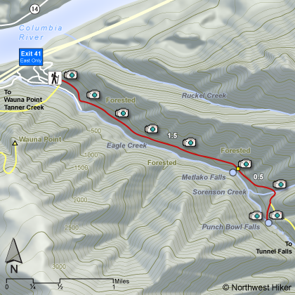
Length: 4.0 miles round trip
Elevation Change: 300' gain
Season: Year Round
Difficulty: Easy
Permit: NW Forest Pass Required
Features:
I decided to include this hike as a separate
hike even though it is on the Eagle Creek Trail. There are many
outstanding destinations on this trail, and most are covered on
Hike 37.
This hike begins at the Eagle Creek trailhead and follow the trail
for about a mile and a half. Going upstream there are not clear
markings indicating that you have arrived at the cutoff trail that
takes you to the overlook for Metlako Falls. However, after you
pass the cutoff trail, you will come to a sign on a tree indicating
the trail to the Metlako Falls overlook. Its but a short back-track,
so its no big deal.
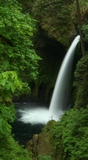
After enjoying Metlako Falls, just return to the main Eagle Creek
Trail and continue upstream. You will soon cross a small creek,
and then come to the cutoff trail that leads down to Eagle Creek
and an area just below Punchbowl Falls. This is the way to truly
enjoy this marvelous falls.
 The trail descends steeply to Eagle Creek, and if the creek is low
you can walk to a place upstream where you can view Punchbowl Falls
from creek level. If the water is high, do NOT UNDER ANY CIRCUMSTANCES
try to wade to a point where you can view the falls. High water
is too dangerous. This falls can be viewed from the Eagle Creek Trail.
The trail descends steeply to Eagle Creek, and if the creek is low
you can walk to a place upstream where you can view Punchbowl Falls
from creek level. If the water is high, do NOT UNDER ANY CIRCUMSTANCES
try to wade to a point where you can view the falls. High water
is too dangerous. This falls can be viewed from the Eagle Creek Trail.
Actually, after this side trip, just walk back up to the main trail, and
follow it just a bit further upstream to the overlook for Punchbowl Falls.

|
|
|
The following images are random samples of the wildflowers found in the Columbia River Gorge National Scenic Area.
Mouseover image to view flower name, and click on image to jump to flower guide.
|
Directions:
From Portland, OR
From Portland, travel east on Interstate Hwy 84 to Exit
Click on the link below to see a map taking you to the trailhead.
|
|
|
|
 |


