THE FOLLOWING MAPS ARE NOT TO BE USED FOR NAVIGATIONAL PURPOSES.
View the slideshow for more sequential photos of this hike.
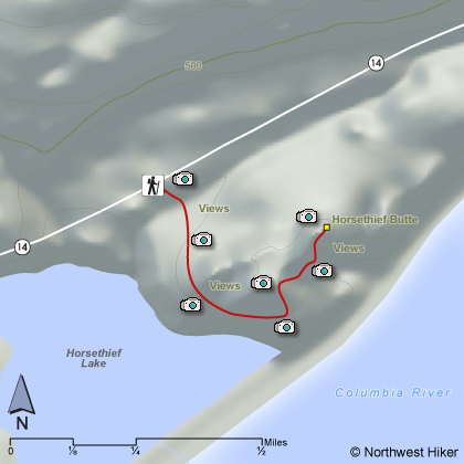
Length: 1.5 miles RT Elevation Change: 150 feet Season: Late winter thru late fall Difficulty: Easy Permit: Pass Not Required Features:
Here is a little hike that offers fun surprises and some
challenges. Located within the Columbia Hills State Park,
this little hike takes you to the top of Horsethief Butte.
In season there can be an abundance of flowers. Always be
alert for rattlesnakes and ticks.
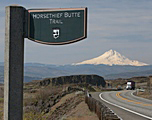
The trailhead is marked clearly along SR14 just a mile
past the entrance to Horsethief Lake State Park and the
Indian Petroglyphs. The trail begins right at the roadside and
heads south along the western and southern flank of Horsethief
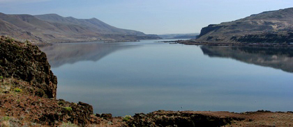
Butte. Weather permitting, one gets excellent views of
Mt. Hood as your look beyond Horsethief Lake to the west/southwest.
The floral displays vary by season, but in the spring they
are best and very enjoyable. As one follows the trail around
the butte to the southern exposure, you will see the trail
leading up between two distinct sides of the butte. Follow
the trail into this area and you will be presented with
barely visible Indian Pictographs. Do not disturb.
To climb on top of Horsethief Butte, choose any one of the
user trails that lead to the summit, which is basically flat
with excellent views in all directions.
The following images are random samples of the wildflowers found in the Columbia River Gorge National Scenic Area.
Mouseover image to view flower name, and click on image to jump to flower guide.


 View the slideshow for more sequential photos of this hike.


 The trailhead is marked clearly along SR14 just a mile
past the entrance to Horsethief Lake State Park and the
Indian Petroglyphs. The trail begins right at the roadside and
heads south along the western and southern flank of Horsethief
Butte. Weather permitting, one gets excellent views of
Mt. Hood as your look beyond Horsethief Lake to the west/southwest.
The trailhead is marked clearly along SR14 just a mile
past the entrance to Horsethief Lake State Park and the
Indian Petroglyphs. The trail begins right at the roadside and
heads south along the western and southern flank of Horsethief
Butte. Weather permitting, one gets excellent views of
Mt. Hood as your look beyond Horsethief Lake to the west/southwest.
 The floral displays vary by season, but in the spring they
are best and very enjoyable. As one follows the trail around
the butte to the southern exposure, you will see the trail
leading up between two distinct sides of the butte. Follow
the trail into this area and you will be presented with
barely visible Indian Pictographs. Do not disturb.
The floral displays vary by season, but in the spring they
are best and very enjoyable. As one follows the trail around
the butte to the southern exposure, you will see the trail
leading up between two distinct sides of the butte. Follow
the trail into this area and you will be presented with
barely visible Indian Pictographs. Do not disturb.