


|
THE FOLLOWING MAPS ARE NOT TO BE USED FOR NAVIGATIONAL PURPOSES.
 View the slideshow for more sequential photos of this hike.
|
Length: 7 miles RT
Elevation Change: 1550 feet
Season: Late winter thru late fall
Difficulty: Challenging
Permit: Pass Not Required
Features: 
Catherine Creek and its various hiking options is one of the most
treasured places in the Columbia River Gorge. Its value lies not
only in the great vistas one can enjoy while hiking here, but its
most important asset is the fact that this is the place we all wait
for all winter long. Because, this is the place where the spring
flowers come out first, at least on a grand scale.
 And as each week after the first or March comes and goes, so do the
wonderful floral displays at this unique and beautiful place. One
could hike here each week of March, April, and May and never see the
same floral displays. Of course, the weather and moisture can vary
this statement, but for the most part it is true! Come and see.
For this review, I am suggesting a fairly less common approach to
hiking at Catherine Creek.
And as each week after the first or March comes and goes, so do the
wonderful floral displays at this unique and beautiful place. One
could hike here each week of March, April, and May and never see the
same floral displays. Of course, the weather and moisture can vary
this statement, but for the most part it is true! Come and see.
For this review, I am suggesting a fairly less common approach to
hiking at Catherine Creek.
 One could park at the usual place where everyone parks, or
one could drive just a bit further east and park at the first
gated road on the left. This road is the beginning of the
trail that I am defining in this review. Park in front of the
gate to one side making room for others, and begin hiking up
the road. In about a half mile, the main road will break off
and head west. You just keep going straight ahead, climbing
along the eastern escarpment of the Catherine Creek sincline.
One could park at the usual place where everyone parks, or
one could drive just a bit further east and park at the first
gated road on the left. This road is the beginning of the
trail that I am defining in this review. Park in front of the
gate to one side making room for others, and begin hiking up
the road. In about a half mile, the main road will break off
and head west. You just keep going straight ahead, climbing
along the eastern escarpment of the Catherine Creek sincline.
 The trail/road will jog a bit to the left (west) as it skirts
private land. Nevetheless, the trail continues climbing along
the west side of Major Creek. As you climb the views just keep
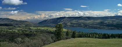
getting better and better. Depending on the weather and the
season, you will be treated to magnificent views of the Columbia
River and Mt. Hood looming to the south. At about 3 miles the
trail will take you through an oak forest then out in the open
again. Here you can walk westward toward Catherine Creek, then
follow the ridge downhill to complete the loop you began.
The trail/road will jog a bit to the left (west) as it skirts
private land. Nevetheless, the trail continues climbing along
the west side of Major Creek. As you climb the views just keep
getting better and better. Depending on the weather and the
season, you will be treated to magnificent views of the Columbia
River and Mt. Hood looming to the south. At about 3 miles the
trail will take you through an oak forest then out in the open
again. Here you can walk westward toward Catherine Creek, then
follow the ridge downhill to complete the loop you began.
|
|
|
The following images are random samples of the wildflowers found in the Columbia River Gorge National Scenic Area.
Mouseover image to view flower name, and click on image to jump to flower guide.
|
Directions:
From Portland, OR
From Portland, travel east on Interstate Hwy 84 to Exit
Click on the link below to see a map taking you to the trailhead.
|
|
|
|
 |


