


|
THE FOLLOWING MAPS ARE NOT TO BE USED FOR NAVIGATIONAL PURPOSES.
 View the slideshow for more sequential photos of this hike.
|
Length: 3 miles round trip
Elevation Change: 400 feet
Season: Late winter thru late fall
Difficulty: Moderate
Permit: Pass Not Required
Features:
 This is one of two hikes that I present for the Cape Horn area. The
other is a short viewpoint hike. This hike takes you down over the
cliffs of the horn, and eventually to a couple of ways to view a
waterfall.
This is one of two hikes that I present for the Cape Horn area. The
other is a short viewpoint hike. This hike takes you down over the
cliffs of the horn, and eventually to a couple of ways to view a
waterfall.
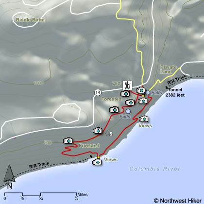
The parking area for this hike option at Cape Horn was not specified
the day I reviewed it. So, just park a bit west of where the trail
drops off over the cliffs, about seven miles east of Washougal, Washington.
It is a bit hard to find at first, but once you do, just park along
SR14 and take the cutoff trail a short distance to the Cape Horn Trail.
This hike is about more than a waterfall or two. It is as much about
views and flowers as anything. Of course, the floral displays are seasonal
and you would be wise to enjoy this hike anytime from April thru July.
However, any time of year is a great opportunity to feast on the views
offered by this unique hike.
 This trail starts out in a dense alder forest.
Just within a short distance, maybe a quarter mile, you will see a
small trail leading off to the left, or east. Follow this trail to
your first great vista of the Columbia River Gorge from this unique
trail. Return to the main trail and continue along the trail to
yet another small trail. Follow this trail also for just a short
distance and you will come to yet another viewpoint on your left. This area
also provides you a view of a beautiful cascading creek, which is
the source of the waterfall that you will eventually end up at on
this very hike.
This trail starts out in a dense alder forest.
Just within a short distance, maybe a quarter mile, you will see a
small trail leading off to the left, or east. Follow this trail to
your first great vista of the Columbia River Gorge from this unique
trail. Return to the main trail and continue along the trail to
yet another small trail. Follow this trail also for just a short
distance and you will come to yet another viewpoint on your left. This area
also provides you a view of a beautiful cascading creek, which is
the source of the waterfall that you will eventually end up at on
this very hike.
After returning to the trail, continue downhill and you will then
cross that little creek you just saw earlier. After the crossing,
you will continue a short distance before you come out in an open
area where the trail parallels the cliff edge. Here you will enjoy
more great vistas of the Columbia River Gorge. The trail then
heads back into the woods and off and on you will be in the open
then in the woods.
 At the lowest point of the hike, you will see a small trail
that will take you about 20 feet or so out onto a most
excellent viewpoint. Here you can look down on the railroad
below you that enters into the tunnel which is part of the
land upon which you are standing. The railroad travels through
a tunnel that is 2382 feet in length, making it the
longest tunnel in the gorge.
At the lowest point of the hike, you will see a small trail
that will take you about 20 feet or so out onto a most
excellent viewpoint. Here you can look down on the railroad
below you that enters into the tunnel which is part of the
land upon which you are standing. The railroad travels through
a tunnel that is 2382 feet in length, making it the
longest tunnel in the gorge.
Returning to the main trail, you will walk just a short distance
to another such overlook. After about a quarter mile, you will
be able to step out on the last overlook of the hike.
After this you begin to climb fairly steeply through a series of
short switchbacks as you approach your destination. The waterfalls
varies in flow, depending on the season. After summer begins,
there is barely any water at all. However, in the spring, the
flow is intense enough to enjoy walking behind the falls, before
you make your return hike to the top of this trail where you began.
This falls is part two of a three tier falls that end up in the Columbia
River. The tallest of the three is not visible from the trail. It
falls below into the river.

|
|
|
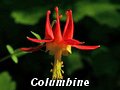
The following images are random samples of the wildflowers found in the Columbia River Gorge National Scenic Area.
Mouseover image to view flower name, and click on image to jump to flower guide.
|
Directions:
From Portland, OR
From Portland, travel east on Interstate Hwy 84 to Exit
Click on the link below to see a map taking you to the trailhead.
|
|
|
|
 |


