


|
THE FOLLOWING MAPS ARE NOT TO BE USED FOR NAVIGATIONAL PURPOSES.
 View the slideshow for more sequential photos of this hike.
|
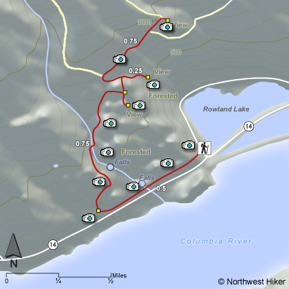
Length: 3 miles round trip
Elevation Change: 500 feet
Season: Late winter thru late fall
Difficulty: Moderate
Permit: Pass Not Required
Features: 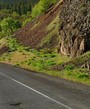
This is a jewell of a little hike not very well known but
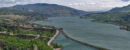
very special. Located on the eastern slope of Coyote Wall,
this hike affords excellent vistas looking east up the
Columbia River Gorge toward Catherine Creek and across at
McCall Point. It has gained the name The Labyrinth by
those who use it.
The best way to approach this hike is to park on the apron
of the old highway 14 at the junction of SR14 and the Old Hwy 14,
which leads to Catherine Creek. Walk west on the old roadbed
for about a half mile. You will walk past a waterfall, which
represents a creek that you will encounter later as you gain
elevation on this hike. In season, this falls is robust.
At about a half mile, you will see a distinct trailheading
uphill to your right. Follow this trail which will lead you
through a wonderful series of small plateaus with park-like
settings. Each season brings its own rewards of flowers
and vistas. At about a half mile you will come to the
creek you saw earlier with the waterfall. Here there are
a number of small cascades and waterfalls to enjoy. Keep
in mind, the flow of water is seasonal.
 This hike is not a designated hike or trail, so it is not
maintained. However, it is very visible and easy to negotiate.
Soon you will come to a plank bridge which takes you over the
little creek you have been following. The trail gets steeper
at this point and climbs around a pronounced cliffy area of
photogenic interest. After passing through a small forest
of white oak, the trail passes yet another plateau. Then
the trail climbs steeply for a short distance before desiring
to make an aburt hard left turn.
This hike is not a designated hike or trail, so it is not
maintained. However, it is very visible and easy to negotiate.
Soon you will come to a plank bridge which takes you over the
little creek you have been following. The trail gets steeper
at this point and climbs around a pronounced cliffy area of
photogenic interest. After passing through a small forest
of white oak, the trail passes yet another plateau. Then
the trail climbs steeply for a short distance before desiring
to make an aburt hard left turn.
It is at this point, you will want to leave this users trail,
and bear to the right, crossing a downed barb wire fence. Keep
on the barely visible path as it leads you to the east and out
on a great viewpoint. This is your destination and reward.
|
|
|
The following images are random samples of the wildflowers found in the Columbia River Gorge National Scenic Area.
Mouseover image to view flower name, and click on image to jump to flower guide.
|
Directions:
From Portland, OR
From Portland, travel east on Interstate Hwy 84 to Exit
Click on the link below to see a map taking you to the trailhead.
|
|
|
|
 |


