


|
THE FOLLOWING MAPS ARE NOT TO BE USED FOR NAVIGATIONAL PURPOSES.
 View the slideshow for more sequential photos of this hike.
|
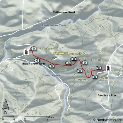
Length: 7 miles round trip
Elevation Change: 1340 feet
Season: Late winter thru late fall
Difficulty: Challenging
Permit: Pass Not Required
Features: 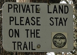
Weldon Wagon Trail is a bit removed from the Columbia River
Gorge, but it is well worth the short drive from SR14 north
on route 141 to the little community of Husom. When you enter Husom, you
will see a sign indicating the need to turn east on Indian Creek Rd.
which will lead you to the trailhead.
 This wagon road was constructed for the purpose of transporting
agricultural products from the surrounding highlands to the
valley below and on to markets. The trail crosses the White Salmon
Oak NRCA (Natural Resources Conservation Area), which includes 315
acres containing one of the larger and remaining forests of Oregon
White Oak. The idea is to preserve the environment of the area to
resemble its appearance prior to settlement.
This wagon road was constructed for the purpose of transporting
agricultural products from the surrounding highlands to the
valley below and on to markets. The trail crosses the White Salmon
Oak NRCA (Natural Resources Conservation Area), which includes 315
acres containing one of the larger and remaining forests of Oregon
White Oak. The idea is to preserve the environment of the area to
resemble its appearance prior to settlement.
 In the spring this little hike is exceptionally great. Late April
and May allows you to enjoy the spring display of the beautiful
balsamroots and lupines. The area is just remote enough that
you are likely to see deer, hawks, and other wildlife which only
adds to the enjoyment of this special place.
In the spring this little hike is exceptionally great. Late April
and May allows you to enjoy the spring display of the beautiful
balsamroots and lupines. The area is just remote enough that
you are likely to see deer, hawks, and other wildlife which only
adds to the enjoyment of this special place.
 Near the summit of the trail, you will be treated to excellent
visitas of Mt. Hood to the south in the state of Oregon. Then
the trail enters a rather dense wooded area before breaking out
into the eastern access trailhead. One can approach this hike
from the east via Sandborn Road. However, to me, it was much
more fun doing the climb from the Husum side.
Near the summit of the trail, you will be treated to excellent
visitas of Mt. Hood to the south in the state of Oregon. Then
the trail enters a rather dense wooded area before breaking out
into the eastern access trailhead. One can approach this hike
from the east via Sandborn Road. However, to me, it was much
more fun doing the climb from the Husum side.

|
|
|
The following images are random samples of the wildflowers found in the Columbia River Gorge National Scenic Area.
Mouseover image to view flower name, and click on image to jump to flower guide.
|
Directions:
From Portland, OR
From Portland, travel east on Interstate Hwy 84 to Exit
Click on the link below to see a map taking you to the trailhead.
|
|
|
|
 |


