THE FOLLOWING MAPS ARE NOT TO BE USED FOR NAVIGATIONAL PURPOSES.
View the slideshow for more sequential photos of this hike.
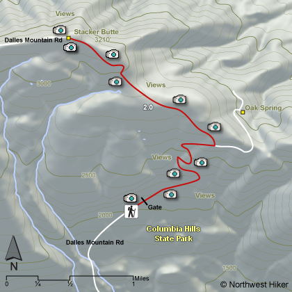
Length: 4 miles round trip Elevation Change: 1120' Season: Late winter thru late fall Difficulty: Moderate Permit: Pass Not Required Features:
The Columbia Hills Natural Area Preserve is the largest NAP
in the state of Washington with 3600 acres. It was established
in 1993 to protect three rare planets: the obscure buttercup,
the Douglas draba, and the hot-rock penstemom.
There is a road hike available at this preserve and it is definately
worth the walk. The trailhead is located about a half mile above
an area called the Dalles Mountain Ranch. The road is gated at
this point and you simply walk up the road in a treeless open
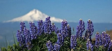
environment. In April and May this area is dripping in wildflowers.
The most common are the Balsamroot and the Lupine. But there are
lots of other species to enjoy and photograph.
One of the highlights to climbing to the 3200 foot summit of this mountain
is the fantastic view of Mt. Adams to the north and Mt. Hood
to the south. There are a number of electronic devices on
this mountain, but they pose no problem to great vistas and
great photos. Use care while hiking in the warmer seasons as
there are rattlesnakes in this area. Also keep in mind that
this area is repleat with ticks. So, use appropriate precautions.
The following images are random samples of the wildflowers found in the Columbia River Gorge National Scenic Area.
Mouseover image to view flower name, and click on image to jump to flower guide.


 View the slideshow for more sequential photos of this hike.


 There is a road hike available at this preserve and it is definately
worth the walk. The trailhead is located about a half mile above
an area called the Dalles Mountain Ranch. The road is gated at
this point and you simply walk up the road in a treeless open
environment. In April and May this area is dripping in wildflowers.
The most common are the Balsamroot and the Lupine. But there are
lots of other species to enjoy and photograph.
There is a road hike available at this preserve and it is definately
worth the walk. The trailhead is located about a half mile above
an area called the Dalles Mountain Ranch. The road is gated at
this point and you simply walk up the road in a treeless open
environment. In April and May this area is dripping in wildflowers.
The most common are the Balsamroot and the Lupine. But there are
lots of other species to enjoy and photograph.
 One of the highlights to climbing to the 3200 foot summit of this mountain
is the fantastic view of Mt. Adams to the north and Mt. Hood
to the south. There are a number of electronic devices on
this mountain, but they pose no problem to great vistas and
great photos. Use care while hiking in the warmer seasons as
there are rattlesnakes in this area. Also keep in mind that
this area is repleat with ticks. So, use appropriate precautions.
One of the highlights to climbing to the 3200 foot summit of this mountain
is the fantastic view of Mt. Adams to the north and Mt. Hood
to the south. There are a number of electronic devices on
this mountain, but they pose no problem to great vistas and
great photos. Use care while hiking in the warmer seasons as
there are rattlesnakes in this area. Also keep in mind that
this area is repleat with ticks. So, use appropriate precautions.