


|
THE FOLLOWING MAPS ARE NOT TO BE USED FOR NAVIGATIONAL PURPOSES.
 View the slideshow for more sequential photos of this hike.
|
Length: 2.6 mi
Elevation Change: 1200'
Season: Almost Year Round
Difficulty: Challenging due to steepness
Permit: No Pass Required
Features: 
Here is one little gem of a hike right along the busy
interstate freeway. Just take exit 58 (eastbound only)
on I84 just few miles west of Hood River, Oregon.
This exit is for access to the Lausmann State Park.
There is a large parking area here, and you will see
a paved trailheaded into the woods at the south end.
Follow this trail, which immediately turns into dirt
path which leads a steep climb to the summit of
Mitchell Point.
 The hike begins in a densely forested area. About a
third of a mile into the climb, you will notice a user
trailheaded off to the left of a steep switchback. You
might want to take this short hike upon your descent from
Mitchell Point. The user trail leads you to the summit
of Mitchell Spur, another steep point with great vistas
of the Columbia River Gorge.
The hike begins in a densely forested area. About a
third of a mile into the climb, you will notice a user
trailheaded off to the left of a steep switchback. You
might want to take this short hike upon your descent from
Mitchell Point. The user trail leads you to the summit
of Mitchell Spur, another steep point with great vistas
of the Columbia River Gorge.
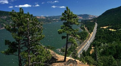
After passing this spur trail, the route up Mitchell Point
continues to climb very steeply. However, you will soon
break out into talus slopes which provide you will
outstanding views of the Columbia River and surrounding
mountains.
About 3/4 mile into the climb, the trail breaks out
into a power line area which is somewhat cleared and
offers more view opportunities. The switchback under
the power line, leads you north onto the summit of
Mitchell Point.
Use caution on this part of the hike, as the summit
has steep and dangerous cliffs on both sides of you.
This hike is not family or pet friendly. USE CAUTION.
|
|
|
The following images are random samples of the wildflowers found in the Columbia River Gorge National Scenic Area.
Mouseover image to view flower name, and click on image to jump to flower guide.
|
Directions:
From Portland, OR
From Portland, travel east on Interstate Hwy 84 to Exit
Click on the link below to see a map taking you to the trailhead.
|
|
|
|
 |


