


|
THE FOLLOWING MAPS ARE NOT TO BE USED FOR NAVIGATIONAL PURPOSES.
 View the slideshow for more sequential photos of this hike.
|
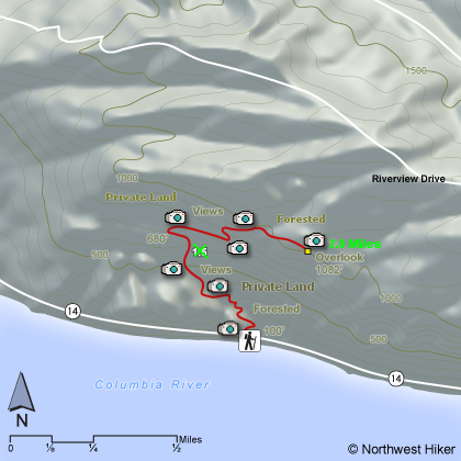
Length: 4 miles round trip
Elevation Change: 982'
Season: Late winter thru late fall
Difficulty: Challenging
Permit: No Pass Required
Features: 
Here is a trail that is provided by a private individual and is
therefore on private land. The kindness of this family allows
those of us who love the Gorge to enjoy even more of its precious
wonders.
Please Note: In 2008 this trail was altered
to prevent erosion, so my maps and photos and details are not
accurate for the first mile or so.
The trailhead is about a mile east of Lyle, Washington on SR14.
After passing through a couple of small tunnels, you will see
the parking area on your left on the north side of the highway.
The trail begins in a dense oak forest that is overflowing in
poison oak.... so beware.
 Shortly, you will come to an old roadbed, and the trail bears
to the left. Soon you will come to a sign, designating this
trail as the Cherry Orchard Trail. The trail is almost always
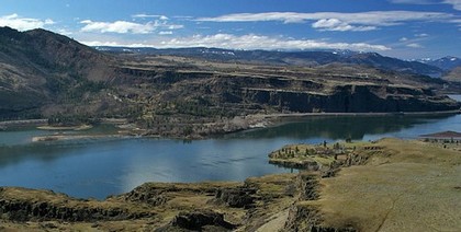
steep, but most of the time it is out in the open and this
provides stunning vistas of the Columbia River Gorge, in all
directions.
Shortly, you will come to an old roadbed, and the trail bears
to the left. Soon you will come to a sign, designating this
trail as the Cherry Orchard Trail. The trail is almost always
steep, but most of the time it is out in the open and this
provides stunning vistas of the Columbia River Gorge, in all
directions.
As the trail climbs out of the valley toward the ridge above you,
there will be various opportunities to stray off the main trail
and explore nearby optional views, flowers, and or wildlife.
Be advised, this trail not only is surrounded by poison oak, but
there are more than an abundant number of ticks, and in the warm
season, rattlesnakes. USE EXTREME CAUTION.
As the trail reaches the ridgeline, I consider this the end of the
hike. The views are wonderful, and in season the floral displays
are rewarding. Simply retrace your steps back to the trailhead to
complete yet another wonderful adventure.
|
|
|
The following images are random samples of the wildflowers found in the Columbia River Gorge National Scenic Area.
Mouseover image to view flower name, and click on image to jump to flower guide.
|
Directions:
From Portland, OR
From Portland, travel east on Interstate Hwy 84 to Exit
Click on the link below to see a map taking you to the trailhead.
|
|
|
|
 |


