MOVE MOUSE OVER MAP CAMERA ICONS ( ) TO VIEW PHOTOS - F5 TO REFRESH ) TO VIEW PHOTOS - F5 TO REFRESH
A PICTURE IS WORTH A THOUSAND WORDS

TRAIL POSITIONED PHOTOS OF THE HIKE |
NOT TO BE USED FOR NAVIGATIONAL PURPOSES - ONLY FOR REFERENCE
 |
|
|
|
| Hike Length: |
6.4 miles round trip |
| Elev. Change: |
1200' cumulative gain |
| Hike Difficulty: |
Challenging |
| Season: |
Late Spring thru Fall |
|
| Trail Condition: |
Some Good, Some Scramble |
| Trail Access: |
Excellent |
| Trail Signage: |
Good until scramble |
| Features: |
Views and Wildflowers |
|
| Useage: |
Light |
| Permit: |
NW FP Required |
| Horses: |
No |
| Mtn Bikes: |
No |
|
|
Summary:
Press CTRL + P to print. Photos do not show when you print this page. (Help)
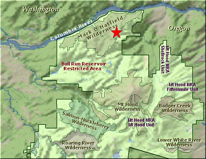
This is one of many hikes in the Wahtum Lake area and it is a bit different than almost
all the other trails on this hiking guide CD. The thing that makes this hike different,
is the need to follow a users trail for the last mile or so, rather than a legitimate
Forest Service numbered trail.
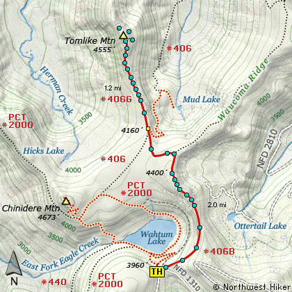
Just like the Mud Lake hike, the trail begins right behind the outhouse at the parking area for Wahtum Lake.
A moderate climb through a dense forest of fir and hemlock will take you to the top of a ridge. As you near
the top of the ridge, you can look back at fantastic views of Mt. Hood to the south, Wahtum Lake, Indian
Mountain, Chinidere Mountain, and Tanner Butte to the west. Once you reach the ridge top,
you can even see Mt. Adams peeking over Green Point Mountain to the northeast.
You will cross an old unused road that used to service Wahtum Lake and fire lookouts on the nearby hilltops.
A trail now follows that old road along Waucoma Ridge to the east and to Rainy Lake. The trail to Tomlike Mountain
begins to descend as you enter the Mark O Hatfield Wilderness Area. Shortly you will come to a junction of Trail #406.
You will be on the edge of a ridge that runs north to Tomlike Mountain.
 The user trail out to Tomlike Mtn is feeble at best, but because most of the hike is out in the
open, you really don't need a trail. Just aim at the mountain (highest point ahead of you).
The one challenge is finding your way through a grove of scrub pine. Someone has cut a good
path through the trees and you shouldn't have too much trouble finding it.
The user trail out to Tomlike Mtn is feeble at best, but because most of the hike is out in the
open, you really don't need a trail. Just aim at the mountain (highest point ahead of you).
The one challenge is finding your way through a grove of scrub pine. Someone has cut a good
path through the trees and you shouldn't have too much trouble finding it.
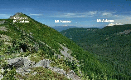
From the top of Tomlike Mtn you get a 360 degree view.... all beautiful. (Click on the Panoview above). Mud Lake is below
you and to the southeast; Mt Hood to the south, Tanner Butte to the west, Mt St Helens to the
northwest; Mt Rainier to the north; Mt Adams to the northeast; Mt Defiance to the east.
|
|
The following images are random samples of the wildflowers found in the Mount Hood National Forest.
Mouseover image to view flower name, and click on image to jump to flower guide.
|
Directions:
These directions take you from Hood River, Oregon.
Whatever direction from which you arrive at Hood River,
follow the sign of old US Hwy 30 into town. From the
west turn right on 13th Street and follow it up the
hill until it merges with 12th. If you are approaching
from the east, on US 30, turn left on 9th and follow it
up the hill until it merges with 12th. Either way,
follow 12th south out of town on what is called
Tucker Road or Hwy 281. About 6 miles out of town you
will cross the Hood River. Immediately after the bridge,
bear right and pass Tucker Park. In about another
six miles you need to bear to the right again following
signs to Lost Lake. This community is referred to as Dee.
As soon as you cross the railroad tracks, bear left and follow the signs to
Lost Lake. This paved road becomes Forest Road 18, and
you need to follow it about another 5 miles. Then
bear right on Forest Road 13 for another 4 miles. Again,
bear right on Forest Road 1310 Forest Road 1310 get a bit narrow in
places, especially where it is exposed to the south.
Be extremely cautious while driving this section of
the road and stay away from the cliff side.
Continue on FR1310 for about another 6 miles to the trailhead parking area
at Wahtum Lake. This is the trailhead for several hikes.
Click on the link below to see a map taking you to the trailhead.
|
|
|


