Summary:
Press CTRL + P to print. Photos do not show when you print this page. (Help)
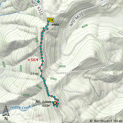
 The Rhododendron Trail #564 runs a little over 11 miles, north and south, along a ridge that
bears its name. The Hawk Mountain hike begins at the southern end of the trail, and this
hike, the Mount Lowe hike, begins at the very northern end of the trail. The trail loosely
follows the old historic Skyline Trail built way back in the early part of last century.
The Rhododendron Trail #564 runs a little over 11 miles, north and south, along a ridge that
bears its name. The Hawk Mountain hike begins at the southern end of the trail, and this
hike, the Mount Lowe hike, begins at the very northern end of the trail. The trail loosely
follows the old historic Skyline Trail built way back in the early part of last century.
I guess the one good thing about all the logging roads is that we hikers can have easy access
to some really special places that we simply would not see if it weren't for the ease of getting there.
This hike is such a hike. The road was very good most of the way. There was some winter damage,
but it was minimal. We found the trailhead easily enough, even though there was absolutely no
sign, ribbon, marker, or any other hint that we were in the right place, except for our map said
that this had to be the start of the trail. And it was.
The one big hint is an unmarked road taking off up the ridge. Actually, you can drive up it
a short distance and park. Then walk a bit further up what looks like a road, and to your right,
kinda hidden and obscure, is a trail... the trail... the old Skyline Trail, which we now call
Rho Trail #564.
 It is obvious that very few people have hiked this trail in a long time. Yet, surprisingly
the trail was in good condition. We only stepped over a couple of fallen trees, and we constantly
amazed at how well this old trail has survived. The hike is only a mile and a half long, and the
trail climbs very gently along Rho Ridge.
It is obvious that very few people have hiked this trail in a long time. Yet, surprisingly
the trail was in good condition. We only stepped over a couple of fallen trees, and we constantly
amazed at how well this old trail has survived. The hike is only a mile and a half long, and the
trail climbs very gently along Rho Ridge.
As you hike toward Mount Lowe, the trail takes you in and out of the forested areas, but often
comes out into the open so you can catch some great views of Mt. Hood and Mt. Adams to the north.
About a mile into the hike you will come upon, of all things, a road. Yup. You could have driven
here. Sooooo? The hike is a million times more fun and fulfilling then driving your 4x4 to
within a few feet of the summit. OK, a half mile... but you get the point. You are a hiker, right?
 From this point on the trail actually climbs rather vigorously as it takes you to the summit
of Mount Lowe. There are some fine switchbacks on the north flank and you will come out onto
the treeless top to enjoy wonderful views in all directions. If you are here in the morning,
you can get great views of the Bull of the Woods Wilderness just to the west of you.
From this point on the trail actually climbs rather vigorously as it takes you to the summit
of Mount Lowe. There are some fine switchbacks on the north flank and you will come out onto
the treeless top to enjoy wonderful views in all directions. If you are here in the morning,
you can get great views of the Bull of the Woods Wilderness just to the west of you.
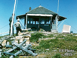
As with about every notable summit in the Cascade Mountains, this mountain also had a fire lookout
on top of it. The photo is a forest service photo from back in the 1950's.
|