MOVE MOUSE OVER MAP CAMERA ICONS ( ) TO VIEW PHOTOS - F5 TO REFRESH ) TO VIEW PHOTOS - F5 TO REFRESH
A PICTURE IS WORTH A THOUSAND WORDS

TRAIL POSITIONED PHOTOS OF THE HIKE |
NOT TO BE USED FOR NAVIGATIONAL PURPOSES - ONLY FOR REFERENCE
 |
|
|
|
| Hike Length: |
4.8 miles round trip |
| Elev. Change: |
1068' gain |
| Hike Difficulty: |
Moderate |
| Season: |
Summer thru Fall |
|
| Trail Condition: |
Good |
| Trail Access: |
Excellent |
| Trail Signage: |
Good |
| Features: |
Views, Wildflowers |
|
| Useage: |
Moderate |
| Permit: |
NW FP NOT Required |
| Horses: |
Yes |
| Mtn Bikes: |
No |
|
|
Summary:
Press CTRL + P to print. Photos do not show when you print this page. (Help)
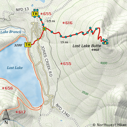
Lost Lake Butte is a must climb if you are camping at the beautiful Lost Lake. This is
a private enterprise and it does cost to enter the grounds. However, if you only want
to climb Lost Lake Butte, you can park just outside the facility and begin on the Trailhead
for Trail #655. This trail begins just outside the fee area where Forest Road 13 junctions
with the access road to the Lost Lake Resort area.
As you begin the hike from outside the park area, you will immediately walk through
a recently logged area and then cross a road used in that logging process. But after
you cross that road, you will enter and remain in a dense lovely forest.
 It is only a short half mile walk to the junction of the trail that leads from Lost Lake to
the butte, and at that point bear left, or uphill, and begin climbing Lost Lake Butte in
earnest.
It is only a short half mile walk to the junction of the trail that leads from Lost Lake to
the butte, and at that point bear left, or uphill, and begin climbing Lost Lake Butte in
earnest.
The trail remains almost entirely in dense forest, so there are no real view
opportunities until you reach the northern ridgeline of the mountain. Even
then, the views are not spectacular until you actually reach the summit. Depending
on the time of year you climb this mountain, your views of the surrounding landscape
will vary considerably.
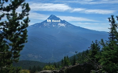
I always try to arrive at a viewpoint at a time of day when the position of the sun
is best for great photographs. However, on this particular hike, I reached the summit
way too early, and the sun left Mt. Hood in deep shadows and I did not get very good
pictures. But good pictures and wonderful scenes are available from this mountain,
and it is so worth the modest effort to enjoy them.
|
|
The following images are random samples of the wildflowers found in the Mount Hood National Forest.
Mouseover image to view flower name, and click on image to jump to flower guide.
|
Directions:
These directions take you from Hood River, Oregon.
Whatever direction from which you arrive at Hood River,
follow the sign of old US Hwy 30 into town. From the
west turn right on 13th Street and follow it up the
hill until it merges with 12th. If you are approaching
from the east, on US 30, turn left on 9th and follow it
up the hill until it merges with 12th. Either way,
follow 12th south out of town on what is called
Tucker Road or Hwy 281. About 6 miles out of town you
will cross the Hood River. Immediately after the bridge,
bear right and pass Tucker Park. In about another
six miles you need to bear to the right again following
signs to Lost Lake. This community is referred to as Dee.
As soon as you cross the railroad tracks, bear left and follow the signs to
Lost Lake. This paved road becomes Forest Road 18, and
you need to follow it about another 8.5 miles. Then
bear right on Forest Road 13 for another 4.5 miles.
Just before you get to the Lost Lake recreation area, and
before you pass through the toll gate, at the place where
Forest Rd 13 bears to the right and heads west, you will
see a small sign on a tree next to the road that says, "Skyline Trail."
Park here, or near hear. Be sure to not block any roadways.
Click on the link below to see a map taking you to the trailhead.
|
|
|


