Summary:
Press CTRL + P to print. Photos do not show when you print this page. (Help)
 Please note: The road to this trailhead was impassable as of 06/11.
If it is not repaired by the time you choose this hike, you can park just beyond the Cast
Lake trailhead and walk along the road to the trailhead for this hike. This will add about
a mile and a half mile each way, and is still definitely worth the extra distance. Actually,
you might consider making a long loop hike by combining the Cast Lake hike with this hike.
Please note: The road to this trailhead was impassable as of 06/11.
If it is not repaired by the time you choose this hike, you can park just beyond the Cast
Lake trailhead and walk along the road to the trailhead for this hike. This will add about
a mile and a half mile each way, and is still definitely worth the extra distance. Actually,
you might consider making a long loop hike by combining the Cast Lake hike with this hike.
For current road/trail conditions call the Zigzag Ranger Station: 503.622.3191
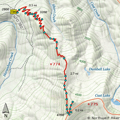
This hike can begin in a number of places. For this narrative I begin the hike on
Forest Road 382 about a half mile from FR 1825 and just a bit past Riley Horse Camp.
If the road is still out past the Cast Creek trailhead, then you will need to park
at the Cast Creek trailhead and hike the road, or what is left of it, to the actual
trailhead for Horseshoe Ridge.
The trail is a steep climb through mostly dense forest and a large number of steep
switchbacks for nearly 3 miles before it reaches Trail #775 on Zig Zag Mountain.
At this junction, bear left, or north on Trail #775 and climb uphill until you can
clearly see a viewpoint off to your left. Leave the main trail and walk the short
distance to this summit, which is the destination of this hike.
There is an abundance of wildflowers in season, but the reward is at the
top. Even if you miss the grand display of Beargrass, on a clear day you will be treated
to fantastic vistas of Mt Hood, Mt Adams, St Helens, and Jefferson to the south.
|