MOVE MOUSE OVER MAP CAMERA ICONS ( ) TO VIEW PHOTOS - F5 TO REFRESH ) TO VIEW PHOTOS - F5 TO REFRESH
A PICTURE IS WORTH A THOUSAND WORDS


TRAIL POSITIONED PHOTOS OF THE HIKE |
NOT TO BE USED FOR NAVIGATIONAL PURPOSES - ONLY FOR REFERENCE
 |
|
|
|
| Hike Length: |
9 miles round trip |
| Elev. Change: |
2800' gain |
| Hike Difficulty: |
Difficult |
| Season: |
Summer thru Fall |
|
| Trail Condition: |
Fair |
| Trail Access: |
Fair |
| Trail Signage: |
Poor |
| Features: |
Views, Wildflowers. Lake |
|
| Useage: |
Light |
| Permit: |
NW FP Required |
| Horses: |
Yes |
| Mtn Bikes: |
No |
|
|
Summary:
Press CTRL + P to print. Photos do not show when you print this page. (Help)
 This challenging hike begins with a very steep climb through
dense forest for about a mile. Then the trail levels off for about a mile before it begins
its upward climb to an open ridge that offer spectacular views of Mt Hood, Mt Adams,
and Mt Rainier.
This challenging hike begins with a very steep climb through
dense forest for about a mile. Then the trail levels off for about a mile before it begins
its upward climb to an open ridge that offer spectacular views of Mt Hood, Mt Adams,
and Mt Rainier.
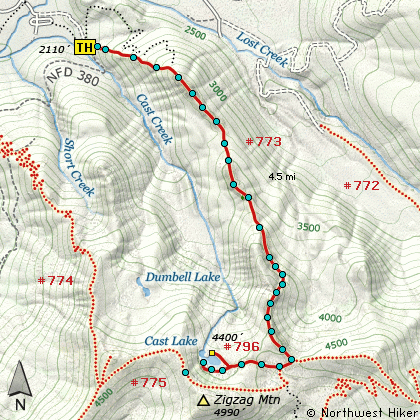
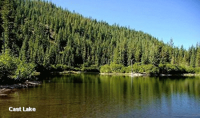
At 3.5 miles the trail intersects trail #775 and follows this trail
for about a quarter mile. Then trail #796 takes you to Cast Lake. As you near the
lake, the trail divides. Going to the right takes you to the far north end of the
lake and decent camping areas. The trail to the left brings you to the south end
of the lake with no appropriate places to camp.
|
|
The following images are random samples of the wildflowers found in the Mount Hood National Forest.
Mouseover image to view flower name, and click on image to jump to flower guide.
|
Directions:
Follow US Highway 26 three miles east of the Mt Hood Information Center
in Welches. Turn north (left) onto the Lolo Pass Road (road 18) at
Zig Zag (across Hwy 26 from Zig Zag Pizza). Follow the road for 4
miles. Turn east (right) onto Road 1825 and continue for .6 miles.
Turn right across a bridge over the Sandy River and continue another
half mile to the junction to Riley Horse Camp. Bear right,
and follow the road a short distance toward the camp, but just
before the camp entrance, bear to the left and follow Road 382
(380 on some maps) another quarter mile where you should see the trailhead is on your left.
When I last visited this site, there were no trailhead signs. So, watch carefully for the trail.
Click on the link below to see a map taking you to the trailhead.
|
|


